|
COMETS EARTH JUPITER KUIPER BELT MARS MERCURY METEORITES NEPTUNE OORT CLOUD PLUTO SATURN SOLAR SYSTEM SPACE SUN URANUS VENUS ORDER PRINTS
PHOTO CATEGORIES SCIENCEVIEWS AMERICAN INDIAN AMPHIBIANS BIRDS BUGS FINE ART FOSSILS THE ISLANDS HISTORICAL PHOTOS MAMMALS OTHER PARKS PLANTS RELIGIOUS REPTILES SCIENCEVIEWS PRINTS
|
Related Document
Download Options
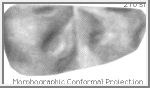
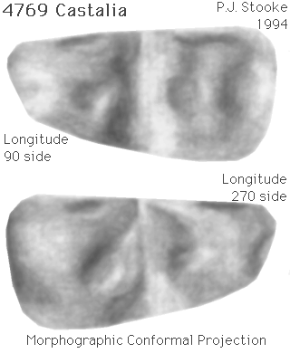
This image is a shaded relief map of asteroid 4769 Castalia, previously known as 1989 PB. As with all maps, it is the cartographer's interpretation and not all features are necessarily certain given the limited data available - this interpretation stretches the data as far as is feasible. This map has not yet been published. Castalia was discovered by E. Helin on 9 August 1989, and imaged at very low resolution by delay-doppler radar at Goldstone and Arecibo later in August 1989. Images are described in: Ostro, S.J., Chandler, J.F., Hine, A.A., Rosema, K.D., Shapiro, I.I. and Yeomans, D.K., 1990. "Radar Images of Asteroid 1989 PB". SCIENCE, v. 248, pp. 1523-1528. A spherical harmonic model of the shape of Castalia was derived from the radar images and is described in: Hudson, R.S. and Ostro, S.J., 1994. "Shape of Asteroid 4769 Castalia (1989 PB) from Inversion of Radar Images". SCIENCE, v. 263, pp. 940-943. I used the published rendered images of that shape model to derive a digital shape model (radii at regular increments of latitude and longitude). The digital model was constrained by the positions of edges and other features in the rendered images, as if they were limbs in spacecraft images. Positions in the map are controlled by the digital shape model. For this map, the three dimensional convex hull of the shape model was projected into the Morphographic Conformal Projection (the conventional Stereographic Projection modified for non-spherical worlds). Longitudes are arbitrary, but for consistency with maps of other small bodies the prime meridian (longitude 0) has been placed at one end of the elongated body. This is 60 degrees west of the prime meridian as defined by Hudson and Ostro. As with all conformal (true shape) projections, the scale in these maps varies, increasing from the centre to the outer edge. Because the model is represented as its convex hull, the deep valley separating two lobes of the asteroid is shown only by shading. Surface features are based on the rendered images, and the 'dimples' are not necessarily to be considered as impact craters, though some probably are. The map projection is described in: Stooke, P.J. and Keller, C.P., 1990. "Map Projections for Non-Spherical Worlds / the Variable-Radius Map Projections", CARTOGRAPHICA, V. 27, No. 2, pp. 82-100. This version of the file, with labels intact, is in the public domain. Philip Stooke, Department of Geography, University of Western Ontario, London, Ontario, Canada N6A 5C2 stooke@sscl.uwo.ca |