|
COMETS EARTH JUPITER KUIPER BELT MARS MERCURY METEORITES NEPTUNE OORT CLOUD PLUTO SATURN SOLAR SYSTEM SPACE SUN URANUS VENUS ORDER PRINTS
PHOTO CATEGORIES SCIENCEVIEWS AMERICAN INDIAN AMPHIBIANS BIRDS BUGS FINE ART FOSSILS THE ISLANDS HISTORICAL PHOTOS MAMMALS OTHER PARKS PLANTS RELIGIOUS REPTILES SCIENCEVIEWS PRINTS
|
Related Document
Download Options
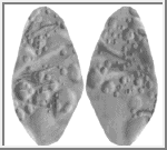
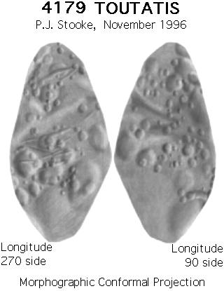
This image is a shaded relief map of asteroid 4179 Toutatis. As with all maps, it is the cartographer's interpretation and not all features are necessarily certain given the limited data available - this interpretation stretches the data as far as is feasible. This map has not yet been published. Toutatis was imaged by delay-doppler radar at Goldstone and Arecibo in December 1992. Images are described in:
Ostro, S.J. et al., 1995. "Radar Images of Asteroid 4179 Toutatis". SCIENCE, v. 270, pp. 80-83. A polyhedral model of the shape of Toutatis was derived from the radar images and is described in: Hudson, R.S. and Ostro, S.J., 1995. "Shape and Non-Principal Axis Rotation of Asteroid 4179 Toutatis". SCIENCE, v. 270, pp. 84-86. I used the published rendered images of that shape model to derive a preliminary digital shape model (radii at regular increments of latitude and longitude). The digital model was further constrained by the positions of radar limbs and terminators and other features in the original images. The viewing geometry for the published images is perpendicular to the radar line of sight. Some images must be mirror-reversed left to right to correspond to the shape model, and the frequency axes on some of the higher resolution images must be modified to fit the model because of slight errors in the assumed rotation state. The 1996 observations should help improve the model and map. A paper on the process is in preparation. Positions in the map are controlled by the digital shape model. For this map, the three dimensional convex hull of the shape model was projected into the Morphographic Conformal Projection (the conventional Stereographic Projection modified for non-spherical worlds). Longitudes are arbitrary, but for consistency with maps of other small bodies the prime meridian (longitude 0) has been placed at one end of the intermediate axis. As with all conformal (true shape) projections, the scale in these maps varies, increasing from the centre to the edges. The map projection is described in:
Stooke, P.J. and Keller, C.P., 1990. "Map Projections for Non-Spherical Worlds / the Variable-Radius Map Projections", CARTOGRAPHICA, V. 27, No. 2, pp. 82-100. This version of the file, with labels intact, is in the public domain. Philip Stooke, Department of Geography, University of Western Ontario, London, Ontario, Canada N6A 5C2 stooke@sscl.uwo.ca |