|
COMETS EARTH JUPITER KUIPER BELT MARS MERCURY METEORITES NEPTUNE OORT CLOUD PLUTO SATURN SOLAR SYSTEM SPACE SUN URANUS VENUS ORDER PRINTS
PHOTO CATEGORIES SCIENCEVIEWS AMERICAN INDIAN AMPHIBIANS BIRDS BUGS FINE ART FOSSILS THE ISLANDS HISTORICAL PHOTOS MAMMALS OTHER PARKS PLANTS RELIGIOUS REPTILES SCIENCEVIEWS PRINTS
|
Related Document
Download Options
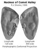
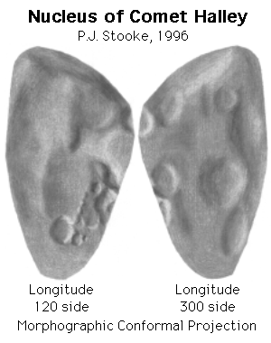
This is a shaded relief map of the nucleus of Comet 1/P Halley. As with all maps, it is the cartographer's interpretation and not all features are necessarily certain given the limited data available - this interpretation stretches the data as far as is feasible. The original map will be published in its full form with relief contours, a latitude-longitude grid, etc. in a forthcoming paper. Positions in the map are controlled by a digital shape model, to be described in that paper. For this map, the three dimensional convex hull of the shape model was projected into the Morphographic Conformal Projection (the conventional Stereographic Projection modified for non-spherical worlds). North is at the top in this map. The prime meridian is defined arbitrarily, but such that the central longitude in the first high resolution Vega 2 image is 270 degrees. Since the rotation about the long axis is from east to west, longitudes increase towards the east (right) in accordance with planetary cartographic convention. As with all conformal (true shape) projections, the scale in these maps varies, increasing from the centre to the outer edge. Halley is a particularly difficult object to map, given the nature of the data available. Many other interpretations might be possible. This relief drawing represents an attempt to show features visible on the disk in various spacecraft images, and the various ridges and hollows suggested by limb topography. Future work will involve attempting to locate active regions on the surface. My colleague Alain Abergel provided pointing data and other help throughout this mapping project, but any flaws in the map are entirely my responsibility. The map projection is described in: Stooke, P.J. and Keller, C.P., 1990. "Map Projections for Non-Spherical Worlds / the Variable-Radius Map Projections", CARTOGRAPHICA, V. 27, No. 2, pp. 82-100. This version of the file, with labels intact, is in the public domain. Philip Stooke, Department of Geography, University of Western Ontario, London, Ontario, Canada N6A 5C2 stooke@sscl.uwo.ca |