|
COMETS EARTH JUPITER KUIPER BELT MARS MERCURY METEORITES NEPTUNE OORT CLOUD PLUTO SATURN SOLAR SYSTEM SPACE SUN URANUS VENUS ORDER PRINTS
PHOTO CATEGORIES SCIENCEVIEWS AMERICAN INDIAN AMPHIBIANS BIRDS BUGS FINE ART FOSSILS THE ISLANDS HISTORICAL PHOTOS MAMMALS OTHER PARKS PLANTS RELIGIOUS REPTILES SCIENCEVIEWS PRINTS
|
Related Document
Download Options
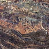
142 million years ago, an asteroid or comet slammed into what is now the Missionary Plains in Australia's Northern Territory, forming a crater 24 kilometers in diameter and 5 kilometers deep. Today, like a bull's eye, the circular ring of hills that defines Gosses Bluff stands as a stark reminder of the event. The crater is located just south of MacDonnel Ranges (top of the picture). It is highly eroded. The circular ring of hills is actually (5 kilometers or 3 miles diameter) the results from differential erosion of the central uplift within this large complex crater. The crater rim is eroded to the point that it is no longer visible although is probably located along the grayish colored drainage system outside the inner ring. |