|
COMETS EARTH JUPITER KUIPER BELT MARS MERCURY METEORITES NEPTUNE OORT CLOUD PLUTO SATURN SOLAR SYSTEM SPACE SUN URANUS VENUS ORDER PRINTS
PHOTO CATEGORIES SCIENCEVIEWS AMERICAN INDIAN AMPHIBIANS BIRDS BUGS FINE ART FOSSILS THE ISLANDS HISTORICAL PHOTOS MAMMALS OTHER PARKS PLANTS RELIGIOUS REPTILES SCIENCEVIEWS PRINTS
|
Related Documents
Download Options
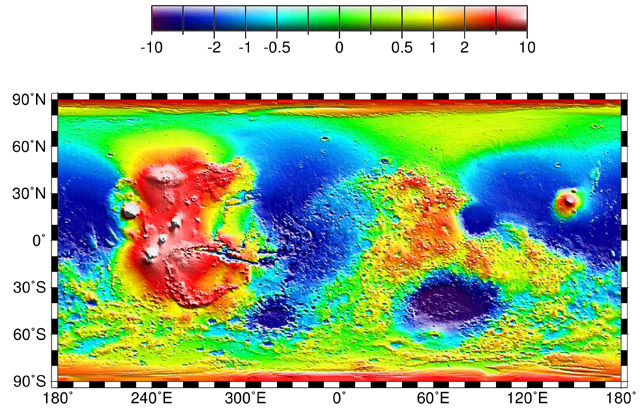
Map of Mars' topography with zonal spherical harmonic degree 1 (COM/COF offset along the polar z-axis axis) removed. The projection is rectangular to show topography from pole to pole. Note the general similarity in elevation between the northern and southern hemispheres. The figure highlights the two other significant components of martian topography: the Tharsis province and the Hellas impact basin. Here we have not removed shorter-wavelength topographic features, including those comprising the dichotomy boundary scarp. |