|
COMETS EARTH JUPITER KUIPER BELT MARS MERCURY METEORITES NEPTUNE OORT CLOUD PLUTO SATURN SOLAR SYSTEM SPACE SUN URANUS VENUS ORDER PRINTS
PHOTO CATEGORIES SCIENCEVIEWS AMERICAN INDIAN AMPHIBIANS BIRDS BUGS FINE ART FOSSILS THE ISLANDS HISTORICAL PHOTOS MAMMALS OTHER PARKS PLANTS RELIGIOUS REPTILES SCIENCEVIEWS PRINTS
|
Related Documents
Download Options
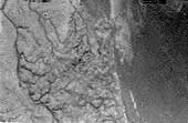
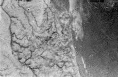
This is one of the first raw images returned by the European Space Agency's Huygens probe during its successful descent to Titan. It was taken at an altitude of 8 kilometers with a resolution of 20 meters per pixel. It shows what could be the landing site, with shorelines and boundaries between raised ground and flooded plains. It was taken with the Descent Imager/Spectral Radiometer, one of two NASA instruments on the probe. |