|
COMETS EARTH JUPITER KUIPER BELT MARS MERCURY METEORITES NEPTUNE OORT CLOUD PLUTO SATURN SOLAR SYSTEM SPACE SUN URANUS VENUS ORDER PRINTS
PHOTO CATEGORIES SCIENCEVIEWS AMERICAN INDIAN AMPHIBIANS BIRDS BUGS FINE ART FOSSILS THE ISLANDS HISTORICAL PHOTOS MAMMALS OTHER PARKS PLANTS RELIGIOUS REPTILES SCIENCEVIEWS PRINTS
|
Related Document
Download Options
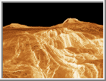
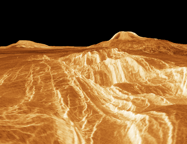
A portion of western Eistla Regio is shown in this three dimensional, computer-generated view of the surface of Venus. The viewpoint is at an elevation of 1.2 kilometers (0.75 mile) at a location 700 kilometers (435 miles) southeast of Gula Mons, the volcano on the right horizon. Gula Mons reaches 3 kilometers (1.8 miles) high and is located around 22 degrees north latitude and 359 degrees east longitude. Sif Mons, the volcano on the left horizon, has a diameter of 300 kilometers (186 miles) and a height of 2 kilometers (1.2 miles). Magellan imaging and altimetry data are combined to develop a three-dimensional computer view of the planet's surface. Simulated color based on color images from the Soviet Venera 13 and 14 spacecraft is added to enhance small-scale structure. This image was produced at JPL's Multimission Image Processing Laboratory by Eric De Jong, Jeff Hall and Myche McAuley. Magellan is a NASA spacecraft mission to map the surface of Venus with imaging radar. The basic scientific instrument is a synthetic aperture radar, or SAR, which can look through the thick clouds perpetually shielding the surface of Venus. Magellan is in orbit around Venus which completes one turn around its axis in 243 Earth days. That period of time, one Venus day, is the length of a Magellan mapping cycle. The spacecraft completed its first mapping cycle and primary mission on May 15, 1991, and immediately began its second cycle. During the first cycle, Magellan mapped more than 80 percent of the planet's surface and the current and subsequent cycles of equal duration will provide complete mapping of Venus. Magellan was launched May 4, 1989, aboard the space shuttle Atlantis and went into orbit around Venus August 10, 1990. This image is in the public domain and is copyright free. |