Uranus I
Ariel [AIR-ee-al] is a relatively small satellite and is the brightest moon of Uranus. The surface is pock-marked with craters, but the most outstanding features are long rift valleys stretching across the entire surface. Canyons much like the ones on Mars appear in the pictures. The canyon floors appear as though they have been smoothed by a fluid. The fluid could not have been water because water acts like steel at these temperatures. The flow marks might have been made by ammonia, methane or even carbon monoxide.
| Ariel Statistics | |
|---|---|
| Discovered by | William Lassell |
| Date of discovery | 1851 |
| Mass (kg) | 1.27e+21 |
| Mass (Earth = 1) | 2.1252e-04 |
| Equatorial radius (km) | 578.9 |
| Equatorial radius (Earth = 1) | 9.0765e-02 |
| Mean density (gm/cm^3) | 1.56 |
| Mean distance from Uranus (km) | 191,240 |
| Rotational period (days) | 2.520379 |
| Orbital period (days) | 2.520379 |
| Mean orbital velocity (km/sec) | 5.52 |
| Orbital eccentricity | 0.0034 |
| Orbital inclination (degrees) | 0.31 |
| Escape velocity (km/sec) | 0.541 |
| Visual geometric albedo | 0.34 |
| Magnitude (Vo) | 14.16 |
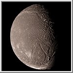
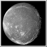
High Resolution Color Image of Ariel
This image of Ariel shows a world pock-marked with craters. Across its
surface long rift valleys extend.
Ariel has canyons similar
to those on Mars, with canyon floors that appear
to have been smoothed by a fluid. The fluid could not have been water
because water acts like steel at these temperatures. The
flow marks might have been made by ammonia, methane or even carbon
monoxide.
(Copyright Calvin J. Hamilton)
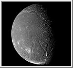 High Resolution Mosaic of Ariel
This image of Ariel is a a composite of four clear filter images
taken by the Voyager 2 spacecraft on January 24, 1986,
from a distance of 130,000 kilometers (80,000 miles).
Two of these images that covered the terminator on the right were
smeared because of the longer exposure times.
Much of Ariel's surface is densely pitted with craters 5 to 1O
kilometers (3 to 6 mi) across. These craters are close to the
threshold of detection in this picture. Numerous valleys and
fault scarps crisscross the highly pitted terrain. Voyager
scientists believe the valleys have formed over down-dropped
fault blocks (graben); apparently, extensive faulting has
occurred as a result of expansion and stretching of Ariel's crust.
The largest fault valleys, near the terminator at right, as well
as a smooth region near the center of this image, have been partly
filled with deposits that are younger and less heavily cratered
than the pitted terrain. Narrow, somewhat sinuous scarps and
valleys have been formed, in turn, in these young deposits. It
is not clear whether these sinuous features have been formed by
faulting or by the flow of fluids.
(Copyright Calvin J. Hamilton)
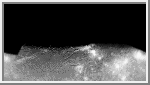 Mercator Map of Ariel
This image is a mercator map of Ariel.
The map covers from 70 to -70 degrees latitude with 0 degree longitude
located at the center. The scale is 2km/pixel at the equator.
(Courtesy A. Tayfun Oner)
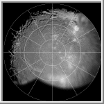 Polar Stereographic Map of Ariel
This image is a polar stereographic map of the southern hemisphere of
Ariel. Zero degrees longitude is at the top. The best
unsmeared Voyager 2 images of Ariel were used in making this map.
(Courtesy A. Tayfun Oner)
 Orthographic View of Ariel
This image is an orthographic view of Ariel centered at -66 degrees latitude
and 316 degrees longitude.
(Courtesy A. Tayfun Oner)

 Uranus
 Miranda
 Umbriel