


|
Prometheus [pra-MEE-thee-us] is the third of Saturn's known satellites. It was discovered from photographs taken by Voyager during its encounter with Saturn by S. Collins and others. Prometheus acts as a shepherd satellite for the inner edge of Saturn's F Ring. The moon is extremely elongated about 145 by 85 by 62 kilometers (90 by 53 by 39 miles) in diameter. It has a number of ridges and valleys on its northern side. Several craters about 20 kilometers (12 miles) in diameter are visible, but it appears to be less cratered than its nearby neighbors Pandora, Janus and Epimetheus. The density of Prometheus has been estimated to be quite low, indicating that is a porous, icy body; however, there is a lot of uncertainty in these values.
| Views of Prometheus |
|---|
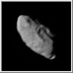
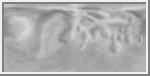
Prometheus
This image of Prometheus was acquired by the Voyager 2 spacecraft on
August 25, 1981.
(Copyright Calvin J. Hamilton)
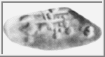 Shaded Relief Map of Prometheus
This image is a shaded relief map of Prometheus, the inner F Ring
Shepherd satellite of Saturn. As with all maps, it is the cartographer's
interpretation and not all features are necessarily certain given the
limited data available. This interpretation stretches the data as far
as is feasible. (Courtesy Phil Stooke)
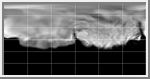 Simple Cylindrical Map of Prometheus
This map of Prometheus was created from Voyager 2 images of the satellite, and the shape model of Phil
Stooke. The map is centered at 0 degrees longitude.
(Courtesy A. Tayfun Oner)
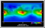 Topographic Map of Prometheus
This is a topographic map of Prometheus. It is based upon the shape model of Phil
Stooke. As with all maps, it is the cartographer's interpretation;
not all features are necessarily certain given the limited data
available. This interpretation stretches the data as far as possible.
(Courtesy A. Tayfun Oner)
 Cylindrical Map of Prometheus
This image is a shaded relief map of Prometheus, the inner F Ring
Shepherd satellite of Saturn. It is the same map as the above image, but
reprojected to the Simple Cylindrical projection. As with all maps, it
is the cartographer's interpretation and not all features are necessarily
certain given the limited data available. This interpretation stretches
the data as far as is feasible.
(Courtesy Phil Stooke)
 Prometheus and Pandora
This image shows Prometheus and Pandora
next to Saturn's F-ring.
(Courtesy NASA/JPL)
| References |
|---|
Stooke, P. J., "Shapes and Surface Features of Prometheus and Pandora," Earth, Moon and Planets, 62 (1993), 199-221.
Copyright © 1997-2000 by Calvin J. Hamilton. All rights reserved. Privacy Statement.

 Saturn
 Atlas
Atlas Pandora