|
COMETS EARTH JUPITER KUIPER BELT MARS MERCURY METEORITES NEPTUNE OORT CLOUD PLUTO SATURN SOLAR SYSTEM SPACE SUN URANUS VENUS ORDER PRINTS
PHOTO CATEGORIES SCIENCEVIEWS AMERICAN INDIAN AMPHIBIANS BIRDS BUGS FINE ART FOSSILS THE ISLANDS HISTORICAL PHOTOS MAMMALS OTHER PARKS PLANTS RELIGIOUS REPTILES SCIENCEVIEWS PRINTS
|
Related Documents
Download Options
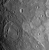
Shortly following MESSENGER's closest approach to Mercury on January 14, 2008, the spacecraft's Narrow Angle Camera (NAC) on the Mercury Dual Imaging System (MDIS) instrument acquired this image as part of a mosaic that covers much of the sunlit portion of the hemisphere not viewed by Mariner 10. Images such as this one can be read in terms of a sequence of geological events and provide insight into the relative timing of processes that have acted on Mercury's surface in the past. The double-ringed crater pictured in the lower left of this image appears to be filled with smooth plains material, perhaps volcanic in nature. This crater was subsequently disrupted by the formation of a prominent scarp (cliff), the surface expression of a major crustal fault system, that runs alongside part of its northern rim and may have led to the uplift seen across a portion of the crater's floor. A smaller crater in the lower right of the image has also been cut by the scarp, showing that the fault beneath the scarp was active after both of these craters had formed. The MESSENGER team is working to combine inferences about the timing of events gained from this image with similar information from the hundreds of other images acquired by MESSENGER to extend and refine the geological history of Mercury previously defined on the basis only of Mariner 10 images. This MESSENGER image was taken from a distance of about 18,000 kilometers (11,000 miles) from the surface of Mercury, at 20:03 UTC, about 58 minutes after the closest approach point of the flyby. The region shown is about 500 kilometers (300 miles) across, and craters as small as 1 kilometer (0.6 mile) can be seen in this image. Credit: NASA/Johns Hopkins University Applied Physics Laboratory/Carnegie Institution of Washington |