When men are arrived at the goal, they should not turn back. - Plutarch
|
Table of Contents |
|
Mercury Science |
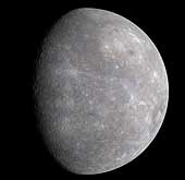
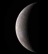
If an explorer were to step onto the surface of Mercury, he would discover a world resembling lunar terrain. Mercury's rolling, dust-covered hills have been eroded from the constant bombardment of meteorites. Fault-cliffs rise for several kilometers in height and extend for hundreds of kilometers. Craters dot the surface. The explorer would notice that the Sun appears two and a half times larger than on Earth; however, the sky is always black because Mercury has virtually no atmosphere to cause scattering of light. As the explorer gazes out into space, he might see two bright stars. One appearing as cream colored Venus and the other as blue colored Earth.
Until Mariner 10, little was known about Mercury because of the difficulty in observing it from Earth telescopes. At maximum elongation it is only 28 degrees from the Sun as seen from Earth. Because of this, it can only be viewed during daylight hours or just prior to sunrise or after sunset. When observed at dawn or dusk, Mercury is so low on the horizon that the light must pass through 10 times the amount of Earth's atmosphere than it would if Mercury was directly overhead.
During the 1880's, Giovanni Schiaparelli drew a sketch showing faint features on Mercury. He determined that Mercury must be tidally locked to the Sun, just as the Moon is tidally locked to Earth. In 1962, radio astronomers looked at radio emissions from Mercury and determined that the dark side was too warm to be tidally locked. It was expected to be much colder if it always faced away from the Sun. In 1965, Pettengill and Dyce determined Mercury's period of rotation to be 59 +- 5 days based upon radar observations. Later in 1971, Goldstein refined the rotation period to be 58.65 +- 0.25 days using radar observations. After close observation by the Mariner 10 spacecraft, the period was determined to be 58.646 +- 0.005 days.
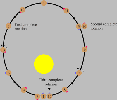
Although Mercury is not tidally locked to the Sun, its rotational period is tidally coupled to its orbital period. Mercury rotates one and a half times during each orbit. Because of this 3:2 resonance, a day on Mercury (sun rise to sun rise) is 176 Earth days long as shown by the following diagram.
 |
|---|
During Mercury's distant past, its period of rotation may have been faster. Scientists speculate that its rotation could have been as rapid as 8 hours, but over millions of years it was slowly despun by solar tides. A model of this process shows that such a despinning would take 109 years and would have raised the interior temperature by 100 degrees Kelvin.
Most of the scientific findings about Mercury comes from the Mariner 10 spacecraft which was launched on November 3, 1973. It flew past the planet on March 29, 1974 at a distance of 705 kilometers from the surface. On September 21, 1974 it flew past Mercury for the second time and on March 16, 1975 for the third time. During these visits, over 2,700 pictures were taken, covering 45% of Mercury's surface. Up until this time, scientists did not suspect that Mercury would have a magnetic field. They thought that because Mercury is small, its core would have solidified long ago. The presence of a magnetic field indicates that a planet has an iron core that is at least partially molten. Magnetic fields are generated from the rotation of a conductive molten core and is known as the dynamo effect.
Mariner 10 showed that Mercury has a magnetic field that is 1% as strong as Earth's. This magnet field is inclined 7 degrees to Mercury's axis of rotation and produces a magnetosphere around the planet. The source of the magnetic field is unknown. It might be produced from a partially molten iron core in the planet's interior. Another source of the field might be from remnant magnetization of iron-bearing rocks which were magnetized when the planet had a strong magnetic field during its younger years. As the planet cooled and solidified remnant magnetization was retained.
Even before Mariner 10, Mercury was known to have a high density. Its density is 5.44 g/cm3 which is comparable to Earth's 5.52g/cm3 density. In an uncompressed state, Mercury's density is 5.5 g/cm3 where Earth's is only 4.0 g/cm3. This high density indicates that the planet is 60 to 70 percent by weight metal, and 30 percent by weight silicate. This gives a core radius of 75% of the planet radius and a core volume of 42% of the planet's volume.
Surface of Mercury
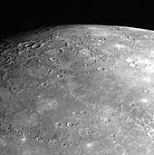
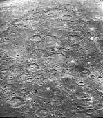
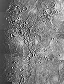
The pictures returned from the Mariner 10 spacecraft showed a world that resembles the moon. It is pocked with craters, contains hugh multi-ring basins, and many lava flows. The craters range in size from 100 meters (the smallest resolvable feature on Mariner 10 images) to 1,300 kilometers. They are in various stages of preservation. Some are young with sharp rims and bright rays extending from them. Others are highly degraded, with rims that have been smoothed from the bombardment of meteorites. The largest crater on Mercury is the Caloris basin. A basin was defined by Hartmann and Kuiper (1962) as a "large circular depression with distinctive concentric rings and radial lineaments." Others consider any crater larger than 200 kilometers a basin. The Caloris basin is 1,300 kilometers in diameter, and was probably caused by a projectile larger than 100 kilometers in size. The impact produced concentric mountain rings three kilometers high and sent ejecta 600 to 800 kilometers across the planet. (Another good example of a basin showing concentric rings is the Valhalla region on Jupiter's moon Callisto.) The seismic waves produced from the Caloris impact focused onto the other side of the planet and produced a region of chaotic terrain. After the impact the crater was partially filled with lava flows.Mercury is marked with great curved cliffs or lobate scarps that were apparently formed as Mercury cooled and shrank a few kilometers in size. This shrinking produced a wrinkled crust with scarps kilometers high and hundreds of kilometers long.
The majority of Mercury's surface is covered by plains. Much of it is old and heavily cratered, but some of the plains are less heavily cratered. Scientists have classified these plains as intercrater plains and smooth plains. Intercrater plains are less saturated with craters and the craters are less than 15 kilometers in diameter. These plains were probably formed as lava flows buried the older terrain. The smooth plains are younger still with fewer craters. Smooth plains can be found around the Caloris basin. In some areas patches of smooth lava can be seen filling craters.
Mercury's history of formation is similar to that of Earth's. About 4.5 billion years ago the planets formed. This was a time of intense bombardment for the planets as they scooped up matter and debris left around from the nebula that formed them. Early during this formation, Mercury probably differentiated into a dense metallic core, and a silicate crust. After the intense bombardment period, lava flowed across the surface and covered the older crust. By this time much of the debris had been swept up and Mercury entered a lighter bombardment period. During this period the intercrater plains formed. Then Mercury cooled. Its core contracted which in turn broke the crust and produced the prominent lobate scarps. During the third stage, lava flooded the lowlands and produced the smooth plains. During the fourth stage micrometeorite bombardment created a dusty surface also known as regolith. A few larger meteorites impacted the surface and left bright rayed craters. Other than the occasional collisions of a meteorites, Mercury's surface is no longer active and remains the same as it has for millions of years.
Could water exist on Mercury?
It would appear that Mercury could not support water in any form. It has very little atmosphere and is blazing hot during the day, but in 1991 scientists at Caltech bounced radio waves off Mercury and found an unusual bright return from the north pole. The apparent brightening at the north pole could be explained by ice on or just under the surface. But is it possible for Mercury to have ice? Because Mercury's rotation is almost perpendicular to its orbital plain, the north pole always sees the sun just above the horizon. The insides of craters would never be exposed to the Sun and scientists suspect that they would remain colder than -161 C. These freezing temperatures could trap water outgassed from the planet, or ices brought to the planet from cometary impacts. These ice deposits might be covered with a layer of dust and would still show bright radar returns.| Mercury Statistics | |
|---|---|
| Mass (kg) | 3.303e+23 |
| Mass (Earth = 1) | 5.5271e-02 |
| Equatorial radius (km) | 2,439.7 |
| Equatorial radius (Earth = 1) | 3.8252e-01 |
| Mean density (gm/cm^3) | 5.42 |
| Mean distance from the Sun (km) | 57,910,000 |
| Mean distance from the Sun (Earth = 1) | 0.3871 |
| Rotational period (days) | 58.6462 |
| Orbital period (days) | 87.969 |
| Mean orbital velocity (km/sec) | 47.88 |
| Orbital eccentricity | 0.2056 |
| Tilt of axis (degrees) | 0.00 |
| Orbital inclination (degrees) | 7.004 |
| Equatorial surface gravity (m/sec^2) | 2.78 |
| Equatorial escape velocity (km/sec) | 4.25 |
| Visual geometric albedo | 0.10 |
| Magnitude (Vo) | -1.9 |
| Mean surface temperature | 179°C |
| Maximum surface temperature | 427°C |
| Minimum surface temperature | -173°C |
| Atmospheric composition
Helium Sodium Oxygen Other | 42% 42% 15% 1% |
- MESSENGER Flies through Mercury's Magnetosphere.
- The Early Formation of Mercury.
- The Final Stages in Mercury's Formation.
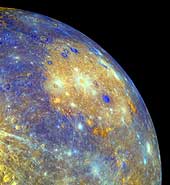
Mercury Shows Its True Colors
MESSENGER's Wide Angle Camera (WAC), part of the Mercury Dual Imaging System (MDIS), is equipped with 11 narrow-band color filters. As the spacecraft receded from Mercury after making its closest approach on January 14, 2008, the WAC recorded a 3x3 mosaic covering part of the planet not previously seen by spacecraft. The color image shown here was generated by combining the mosaics taken through the WAC filters that transmit light at wavelengths of 1000 nanometers (infrared), 700 nanometers (far red), and 430 nanometers (violet). These three images were placed in the red, green, and blue channels, respectively, to create the visualization presented here. The human eye is sensitive only across the wavelength range from about 400 to 700 nanometers. Creating a false-color image in this way accentuates color differences on Mercury's surface that cannot be seen in black-and-white (single-color) images.
Color differences on Mercury are subtle, but they reveal important information about the nature of the planet's surface material. A number of bright spots with a bluish tinge are visible in this image. These are relatively recent impact craters. Some of the bright craters have bright streaks (called "rays" by planetary scientists) emanating from them. Bright features such as these are caused by the presence of freshly crushed rock material that was excavated and deposited during the highly energetic collision of a meteoroid with Mercury to form an impact crater. The large circular light-colored area in the upper right of the image is the interior of the Caloris basin. Mariner 10 viewed only the eastern (right) portion of this enormous impact basin, under lighting conditions that emphasized shadows and elevation differences rather than brightness and color differences. MESSENGER has revealed that Caloris is filled with smooth plains that are brighter than the surrounding terrain, hinting at a compositional contrast between these geologic units. The interior of Caloris also harbors several unusual dark-rimmed craters, which are visible in this image. The MESSENGER science team is working with the 11-color images in order to gain a better understanding of what minerals are present in these rocks of Mercury's crust.
(Courtesy NASA/JHUAPL)
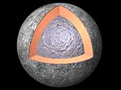 The Interior of Mercury
Most of what is known about the internal structure of Mercury comes from
data acquired by the Mariner 10 spacecraft that flew past the planet
in 1973 and 1974. Mercury is about a third of the size of Earth, yet
its density is comparable to that of Earth. This indicates that Mercury
has a large core roughly the size of Earth's moon or about 75% of
the planet's radius. The core is likely composed of 60 to 70% iron
by mass.
Mariner 10's measurements of the planet reveals a dipolar magnetic field
possibly produced by a partially molten core.
A solid rocky mantle surrounds the core with a thin crust of about 100
kilometers.
(Copyright Calvin J. Hamilton)
 Caloris Basin—in Color!
This false-color image of Mercury, recently published in Science magazine,
shows the great Caloris impact basin, visible in this image
as a large, circular, orange feature in the center of the picture. The
contrast between the colors of the Caloris basin floor and those of the
surrounding plains indicate that the composition of Mercury's surface is
variable. Many additional geological features with intriguing color
signatures can be identified in this image. For example, the bright orange
spots just inside the rim of Caloris basin are thought to mark the
location of volcanic features, such as the volcano shown in image PIA10942.
MESSENGER Science Team members are studying these regional color
variations in detail, to determine the different mineral compositions of
Mercury's surface and to understand the geologic processes that have acted
on it. Images taken through the 11 different WAC color filters were used
to create this false-color image. The 11 different color images were
compared and contrasted using statistical methods to isolate and enhance
subtle color differences on Mercury's surface.
(Courtesy NASA/Johns Hopkins University Applied Physics Laboratory/Arizona State)
 MESSENGER Discovers Volcanoes on Mercury
As reported in the July 4, 2008 issue of Science magazine, volcanoes
have been discovered on Mercury's surface from images acquired during
MESSENGER's first Mercury flyby. This image shows the largest feature
identified as a volcano in the upper center of the scene. The volcano has
a central kidney-shaped depression, which is the vent, and a broad smooth
dome surrounding the vent. The volcano is located just inside the rim of
the Caloris impact basin. The rim of the basin is marked with hills and
mountains, as visible in this image. The role of volcanism in Mercury's
history had been previously debated, but MESSENGER's discovery of the
first identified volcanoes on Mercury's surface shows that volcanism was
active in the distant past on the innermost planet.
(Courtesy NASA/Johns Hopkins University Applied Physics Laboratory/Carnegie Institution of Washington)
 Mercury - in Color!
One week ago, the MESSENGER spacecraft transmitted to Earth the first high-resolution image of Mercury by a spacecraft in over 30 years, since the three Mercury flybys of Mariner 10 in 1974 and 1975. MESSENGER's Wide Angle Camera (WAC), part of the Mercury Dual Imaging System (MDIS), is equipped with 11 narrow-band color filters, in contrast to the two visible-light filters and one ultraviolet filter that were on Mariner 10's vidicon camera. By combining images taken through different filters in the visible and infrared, the MESSENGER data allow Mercury to be seen in a variety of high-resolution color views not previously possible. MESSENGER's eyes can see far beyond the color range of the human eye, and the colors seen in the accompanying image are somewhat different from what a human would see.
The color image was generated by combining three separate images taken through WAC filters sensitive to light in different wavelengths; filters that transmit light with wavelengths of 1000, 700, and 430 nanometers (infrared, far red, and violet, respectively) were placed in the red, green, and blue channels, respectively, to create this image. The human eye is sensitive across only the wavelength range 400 to 700 nanometers. Creating a false-color image in this way accentuates color differences on Mercury's surface that cannot be seen in the single-filter, black-and-white image released last week.
This visible-infrared image shows an incoming view of Mercury, about 80 minutes before MESSENGER's closest pass of the planet on January 14, 2008, from a distance of about 27,000 kilometers (17,000 miles).
(Courtesy NASA/JHUAPL)
 Mercury's Complex Cratering History
On January 14, 2008, the MESSENGER spacecraft observed about half of the hemisphere not seen by Mariner 10. These images, mosaicked together by the MESSENGER team, were taken by the Narrow Angle Camera (NAC), part of the Mercury Dual Imaging System (MDIS) instrument, about 20 minutes after MESSENGER's closest approach to Mercury (2:04 pm EST), when the spacecraft was at a distance of about 5,000 kilometers (about 3,100 miles). The image shows features as small as 400 meters (0.25 miles) in size and is about 370 kilometers (230 miles) across.
The image shows part of a large, fresh crater with secondary crater chains located near Mercury's equator on the side of the planet newly imaged by MESSENGER. Large, flat-floored craters often have terraced rims from post-impact collapse of their newly formed walls. The hundreds of secondary impactors that are excavated from the planet's surface by the incoming object create long, linear crater chains radial to the main crater. These chains, in addition to the rest of the ejecta blanket, create the complicated, hilly terrain surrounding the primary crater. By counting craters on the ejecta blanket that have formed since the impact event, the age of the crater can be estimated. This count can then be compared with a similar count for the crater floor to determine whether any material has partially filled the crater since its formation. With their large size and production of abundant secondary craters, these flat-floored craters both illuminate and confound the study of the geological history of Mercury.
(Courtesy NASA/JHUAPL)
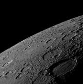
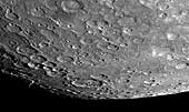 Looking Toward the South Pole of Mercury
On January 14, 2008, the MESSENGER spacecraft passed 200 kilometers (124
miles) above the surface of Mercury and snapped the first pictures of a
side of Mercury not previously seen by spacecraft. This image shows that
previously unseen side, with a view looking toward Mercury's south pole.
The southern limb of the planet can be seen in the bottom right of the image.
The bottom left of the image shows the transition from the sunlit, day side of
Mercury to the dark, night side of the planet, a transition line known as the
terminator. In the region near the terminator, the sun shines on the surface
at a low angle, causing the rims of craters and other elevated surface
features to cast long shadows, accentuating height differences in the image.
This image was acquired about 98 minutes after MESSENGER's closest approach
to Mercury, when the spacecraft was at a distance of about 33,000 kilometers
(21,000 miles).
(Courtesy NASA/JHUAPL)
 MESSENGER Looks to the North
As MESSENGER sped by Mercury on January 14, 2008, the Narrow Angle Camera (NAC) of the Mercury Dual Imaging System (MDIS) captured this shot looking toward Mercury's north pole. The surface shown in this image is from the side of Mercury not previously seen by spacecraft. The top right of this image shows the limb of the planet, which transitions into the terminator (the line between the sunlit, day side and the dark, night side) on the top left of the image. Near the terminator, the Sun illuminates surface features at a low angle, casting long shadows and causing height differences of the surface to appear more prominent in this region.
It is interesting to compare MESSENGER's view to the north with the image looking toward the south pole, released on January 21. Comparing these two images, it can be seen that the terrain near the south pole is more heavily cratered while some of the region near the north pole shows less cratered, smooth plains material, consistent with the general observations of the poles made by Mariner 10. MESSENGER acquired over 1200 images of Mercury's surface during its flyby, and the MESSENGER team is busy examining all of those images in detail, to understand the geologic history of the planet as a whole, from pole to pole.
(Courtesy NASA/JHUAPL)
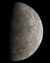 Mariner 10 Outgoing Color Image of Mercury
This mosaic of Mercury was created from more than 140 images taken by the Mariner 10 spacecraft
as it flew past the innermost planet on March 29, 1974. Mariner 10's trajectory brought the
spacecraft across the dark hemisphere of Mercury. The images were acquired after the spacecraft
exited Mercury's shadow. The color data is from more distant global views.
(Copyright Ted Stryk)
 MESSENGER Views Mercury's Horizon
As the MESSENGER spacecraft drew closer to Mercury for its historic first flyby, the spacecraft's Narrow Angle Camera (NAC) on the Mercury Dual Imaging System (MDIS) acquired an image mosaic of the sunlit portion of the planet. This image is one of those mosaic frames and was acquired on January 14, 2008, 18:10 UTC, when the spacecraft was about 18,000 kilometers (11,000 miles) from the surface of Mercury, about 55 minutes before MESSENGER's closest approach to the planet.
The image shows a variety of surface textures, including smooth plains at the center of the image, many impact craters (some with central peaks), and rough material that appears to have been ejected from the large crater to the lower right. This large 200-kilometer-wide (about 120 miles) crater was seen in less detail by Mariner 10 more than three decades ago and was named Sholem Aleichem for the Yiddish writer. In this MESSENGER image, it can be seen that the plains deposits filling the crater's interior have been deformed by linear ridges. The shadowed area on the right of the image is the day-night boundary, known as the terminator. Altogether, MESSENGER acquired over 1200 images of Mercury, which the science team members are now examining in detail to learn about the history and evolution of the innermost planet.
(Courtesy NASA/JHUAPL)
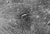 "The Spider" - Radial Troughs within Caloris
The Narrow Angle Camera of the Mercury Dual Imaging System (MDIS) on the MESSENGER spacecraft obtained high-resolution images of the floor of the Caloris basin on January 14, 2008. Near the center of the basin, an area unseen by Mariner 10, this remarkable feature - nicknamed "the spider" by the science team - was revealed. A set of troughs radiates outward in a geometry unlike anything seen by Mariner 10. The radial troughs are interpreted to be the result of extension (breaking apart) of the floor materials that filled the Caloris basin after its formation. Other troughs near the center form a polygonal pattern. This type of polygonal pattern of troughs is also seen along the interior margin of the Caloris basin. An impact crater about 40 km (~25 miles) in diameter appears to be centered on "the spider." The straight-line segments of the crater walls may have been influenced by preexisting extensional troughs, but some of the troughs may have formed at the time that the crater was excavated.
(Courtesy NASA/JHUAPL)
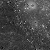
 MESSENGER Reveals Mercury's Geological History
Shortly following MESSENGER's closest approach to Mercury on January 14, 2008, the spacecraft's Narrow Angle Camera (NAC) on the Mercury Dual Imaging System (MDIS) instrument acquired this image as part of a mosaic that covers much of the sunlit portion of the hemisphere not viewed by Mariner 10. Images such as this one can be read in terms of a sequence of geological events and provide insight into the relative timing of processes that have acted on Mercury's surface in the past.
The double-ringed crater pictured in the lower left of this image appears to be filled with smooth plains material, perhaps volcanic in nature. This crater was subsequently disrupted by the formation of a prominent scarp (cliff), the surface expression of a major crustal fault system, that runs alongside part of its northern rim and may have led to the uplift seen across a portion of the crater's floor. A smaller crater in the lower right of the image has also been cut by the scarp, showing that the fault beneath the scarp was active after both of these craters had formed. The MESSENGER team is working to combine inferences about the timing of events gained from this image with similar information from the hundreds of other images acquired by MESSENGER to extend and refine the geological history of Mercury previously defined on the basis only of Mariner 10 images.
(Courtesy NASA/JHUAPL)
 Ridges and Cliffs on Mercury's Surface
A complex history of geological evolution is recorded in this frame from the Narrow Angle Camera (NAC), part of the Mercury Dual Imaging System (MDIS) instrument, taken during MESSENGER's close flyby of Mercury on January 14, 2008. Part of an old, large crater occupies most of the lower left portion of the frame. An arrangement of ridges and cliffs in the shape of a "Y" crosses the crater's floor. The shadows defining the ridges are cast on the floor of the crater by the Sun shining from the right, indicating a descending stair-step of plains. The main, right-hand branch of the "Y" crosses the crater floor, the crater rim, and continues off the top edge of the picture; it appears to be a classic "lobate scarp" (irregularly shaped cliff) common in all areas of Mercury imaged so far. These lobate scarps were formed during a period when Mercury's crust was contracting as the planet cooled. In contrast, the branch of the Y to the left ends at the crater rim and is restricted to the floor of the crater. Both it and the lighter-colored ridge that extends downward from it resemble "wrinkle ridges" that are common on the large volcanic plains, or "maria," on the Moon. The MESSENGER science team is studying what features like these reveal about the interior cooling history of Mercury.
Ghostly remnants of a few craters are seen on the right side of this image, possibly indicating that once-pristine, bowl-shaped craters (like those on the large crater's floor) have been subsequently flooded by volcanism or some other plains-forming process.
(Courtesy NASA/JHUAPL)
 Detailed Close-up of Mercury's Previously Unseen Surface
This scene was imaged by MESSENGER's Narrow Angle Camera (NAC) on the Mercury Dual Imaging System (MDIS) during the spacecraft's flyby of Mercury on January 14, 2008. The scene is part of a mosaic that covers a portion of the hemisphere not viewed by Mariner 10 during any of its three flybys (1974-1975). The surface of Mercury is revealed at a resolution of about 250 meters/pixel (about 820 feet/pixel). For this image, the Sun is illuminating the scene from the top and north is to the left.
The outer diameter of the large double ring crater at the center of the scene is about 260 km (about 160 miles). The crater appears to be filled with smooth plains material that may be volcanic in nature. Multiple chains of smaller secondary craters are also seen extending radially outward from the double ring crater. Double or multiple rings form in craters with very large diameters, often referred to as impact basins. On Mercury, double ring basins begin to form when the crater diameter exceeds about 200 km (about 125 miles); at such an onset diameter the inner rings are typically low, partial, or discontinuous. The transition diameter at which craters begin to form rings is not the same on all bodies and, although it depends primarily on the surface gravity of the planet or moon, the transition diameter can also reveal important information about the physical characteristics of surface materials. Studying impact craters, such as this one, in the more than 1200 images returned from this flyby will provide clues to the physical properties of Mercury's surface and its geological history.
(Courtesy NASA/JHUAPL)
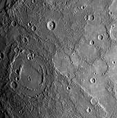
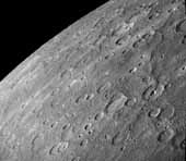
 Hills of Mercury
"Weird terrain" best describes this hilly, lineated region of
Mercury. This area is at the antipodal
point from the large Caloris basin. The shock wave produced by
the Caloris impact was reflected and focused to this antipodal point,
thus jumbling the crust and breaking it into a series of complex blocks.
The area covered is about 100 kilometers (62 miles) on a side.
(Copyright Calvin J. Hamilton; FDS 27370)
 Caloris Basin Floor
This image is a high resolution view of the Caloris Basin shown in the
previous image. It shows ridges and fractures that increase in size
towards the center of the basin (upper left).
(Copyright Calvin J. Hamilton; FDS 126)
 Bright Rayed Craters
This image shows two prominent craters (upper right) with bright halos
on Mercury. The craters are about 40 kilometers (25 miles) in diameter.
The halos and rays cover other features on the surface indicating that
they are some of the youngest on Mercury.
(Copyright Calvin J. Hamilton; FDS 275)
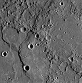
 Large Faults on Mercury
This Mariner 10 image shows Santa Maria
Rupes, the sinuous dark feature
running through the crater at the center of this image. Many such features
were discovered in the Mariner images of Mercury and are interpreted to be
enormous thrust faults where part of the
mercurian crust was pushed slightly over an adjacent part by
compressional forces. The abundance and length of the thrust faults
indicate that the radius of Mercury decreased by 1-2 kilometers
(.6 - 1.2 miles) after the solidification and impact cratering of the
surface. This volume change probably was due to the cooling of the
planet, following the formation of a metallic core three-fourths the
size of the planet. North is towards the top and is 200 kilometers
(120 miles) across.
(© Copyright 1998 by Calvin J. Hamilton; FDS 27448)
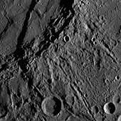
 Antoniadi Ridge
This is an image of a 450 kilometer (280 mile) ridge called Antoniadi.
It travels along the right edge of the image, and transects a large 80
kilometer (50 mile) crater about half way in between. It crosses smooth
plains to the north and intercrater plains to the south
[Strom et al., 1975].
(Copyright Calvin J. Hamilton)
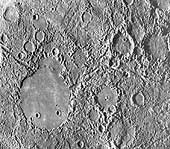
 Double Ring Basin
This image shows a double-ring basin which is 200 kilometers (120 miles)
in diameter. The floor contains smooth plains material. The inner ring
basin is at a lower elevation than the outer ring.
(Copyright Calvin J. Hamilton; FDS 27301)
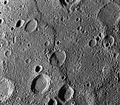
 Incoming View of Mercury
This photomosaic of Mercury was constructed from photos taken by
Mariner 10 six hours before the spacecraft
flew past the planet on March 29, 1974.
These images were taken from a distance of 5,380,000
kilometers (3,340,000 miles).
(Courtesy USGS, and NASA)
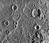
 Mercury
This two image (FDS 26850, 26856) mosaic of Mercury was constructed
from photos taken by Mariner 10 a few hours
before the spacecraft's closest and first encounter with the planet on
March 29, 1974.
(Copyright Calvin J. Hamilton)
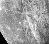
 Caloris Basin
This mosaic shows the Caloris Basin (located half-way in shadow on
the morning terminator). Caloris is Latin for heat and the basin
is named this because it is near the subsolar point (the point closest
to the sun) when Mercury is at aphelion.
Caloris basin is 1,300 kilometers (800 miles) in diameter and is the
largest know structure on Mercury. It was formed from an impact of a
projectile with asteroid dimensions. The interior floor of the basin
contains smooth plains but is highly ridged and fractured. North is
towards the top of this image.
(Copyright Calvin J. Hamilton; FDS 188-199)
Davies, M. E., S. E. Dwornik, D. E. Gault, and R. G. Strom. Atlas of Mercury. NASA SP-423. Washington, D.C.: U.S. Government Printing Office, 1978.
Mariner 10 Preliminary Science Report. Science, 185:141-180, 1974.
Mariner 10 Imaging Science Final Report. Journal of Geophysical Research, 80(17):2341-2514, 1975.
Strom, Robert G. et al. "Tectonism and Volcanism on Mercury." Journal of Geophysical Research, 80(17):2478-2507, 1975.
Trask, Newell J. and John E. Guest. "Preliminary Geologic Terrain Map of Mercury." Journal of Geophysical Research, 80(17):2461-2477, 1975.

 Sun
Sun Venus
Venus