|
COMETS EARTH JUPITER KUIPER BELT MARS MERCURY METEORITES NEPTUNE OORT CLOUD PLUTO SATURN SOLAR SYSTEM SPACE SUN URANUS VENUS ORDER PRINTS
PHOTO CATEGORIES SCIENCEVIEWS AMERICAN INDIAN AMPHIBIANS BIRDS BUGS FINE ART FOSSILS THE ISLANDS HISTORICAL PHOTOS MAMMALS OTHER PARKS PLANTS RELIGIOUS REPTILES SCIENCEVIEWS PRINTS
|
Related Documents
Download Options
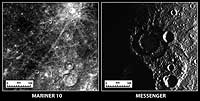
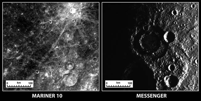
Date Acquired: October 6, 2008 Believe it or not, these two images show the same terrain on Mercury as imaged by Mariner 10 in the 1970s and by the MESSENGER spacecraft on October 6, 2008. The reason it looks so different is that the angle that the Sun illuminates the surface is dramatically different between the two observations. When Mariner 10 acquired the image on the left, the Sun was high in the sky, which highlights the relative differences in brightness between geologic units on the surface. When the Sun is lower in the sky, as was the case during the second MESSENGER Mercury flyby (right image), shadows become more prominent and it is easier to see the rugged topography of the surface. Most noticeably, a peak-ring impact crater with a diameter of about 150 kilometers (93 miles) is clearly seen in new MESSENGER data, whereas it was nearly invisible in Mariner 10 data. Credit: NASA/Johns Hopkins University Applied Physics Laboratory/Carnegie Institution of Washington |