The Earth is a cradle of the mind, but we cannot live forever in a cradle.
- Konstantin E. Tsiolkovsky
|
Table of Contents |
|
Clouds From Space
|
|
Related Information |
Current data suggest that the cooling effects of great masses of cumulus storm clouds over the ocean at mid latitudes outweigh the heating effects of the upper-level cirrus clouds when considered on a global scale. Nevertheless, there is cause for concern because many models of global warming predict a decline in heavy mid-latitude cumulus storm clouds in the future. The amount of high-level cirrus cloud is predicted to rise as the cumulus decreases. If environmental and climatic changes result in altered weather and atmospheric patterns that adhere to these models, such changes will in turn induce accelerated global warming.
 Jet Stream
The Northern Hemisphere Jet Stream can be seen crossing Cape Breton Island in the Maritime
Provinces of Eastern Canada. The Jet Stream is a narrow zone of high-speed winds typically
found at altitudes of 4 to 8 miles (8-12 km) above the earth. They result from temperature
contrasts between polar and tropical regions. The strongest Jet Stream winds are found in
the winter when the contrast between polar and tropical regions is the greatest. Wind speeds
can reach 90 to over 180 miles per hour (145 to over 290 km/h) from west to east. Jet Streams
are found between latitudes 20? to near 55? north and south. During the winter months over
the United States and southern Canada, the path taken by the Jet Stream can have a large
influence on the weather conditions of this region.
(Courtesy NASA)
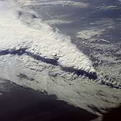 Florida Squall Line
This spectacular,
low-oblique photograph shows a convective line of thunderstorms associated
with a passing cold front over Florida. A shadow from the height of the
thunderstorms, caused by early morning sunlight, can be seen traversing
the scene southwest to northeast. The clouds in the
storm system rise to about 16,500 meters (55,000 feet). The V-shaped cloud
structure is normally associated with cold fronts that cross the Gulf of
Mexico and Florida in late winter and early spring. Severe thunderstorms
and tornadoes usually occur with this type of storm system. At the time
this photograph was taken, weather stations across Florida reported severe
thunderstorms, strong winds, hail, torrential rains, and numerous tornadoes.
(Courtesy NASA)
 Thunderstorms, Brazil
These cumulus thunderheads near São Paulo, Brazil, where
photographed from almost directly overhead by the STS 41-B crew. This
perspective conveys something of the energy that drives these cloud
columns to punch up into the atmosphere. The foreshortening resulting
from the near-vertical viewing angle disguises the fact that the
cloudheads so prominently in view are but the tops of massive thunderhead
storm clouds that can tower up to 18,000 meters (60,000 feet) in the tropics.
(Courtesy LPI/NASA. Picture #11-41-2343)
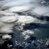 Cumulus Cloud Tops
This oblique photograph, acquired in February 1984 by an astronaut aboard the space shuttle,
shows a series of mature thunderstorms located near the Parana River in southern
Brazil. With abundant warm temperatures and moisture-laden air in this part of
Brazil, large thunderstorms are commonplace. A number of overshooting tops and
anvil clouds are visible at the tops of the clouds. When the rising cumulus columns meet
the tropopause,
or base of the stratosphere, at about 15,000 kilometers (50,000 feet), they
reach a ceiling and can no longer rise buoyantly by convection. The
stable temperature of the stratosphere suppresses further adiabatic
ascent of moisture that has been driven through the troposphere
by the 5-6.8 degree/kilometer (8-11 degree/mile) lapse rate. Instead, ice
clouds spread horizontally into the extended cirrus heads seen in this
photograph, forming the "anvil heads" that we identify from the ground. The finer, feathery
development around the edges of some of the thunderheads is glaciation -
water vapor in the cloud is turning to ice at high altitude. Storms of this magnitude can
drop large amounts of rainfall in a short period of time, causing flash floods.
(Courtesy NASA-JSC)
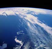
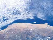
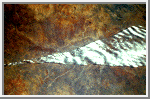
 Cloud Margin, Bering Sea
All that can be seen in this photograph is cloud stretching several hundred
kilometers to the limb of the Earth, yet it tells us a great deal about the
water in the Bering Sea below. The line or cloud margin running diagonally
across the frame with dense, thick cloud to the right and lighter, more
broken cloud to the left reflects an ocean current margin. A difference in
water temperature on either side of the margin is reflected in the cloud
forms condensing above. This striking cloud boundary stretches for 800-960
kilometers (500-600 miles) in this photograph.
(Courtesy LPI/NASA. Picture #17-41-058)
 Coastal Current, Namibia
Condensing moisture from ocean currents in some parts of the world creates
clouds that stay uniformly in position above that current for months at a
time. This example shows clouds hanging above the cold Benguela current,
which travels northward along the Atlantic coast of southwestern Africa. It
is interesting that while the ocean is densely cloud-covered and the clouds
lap at the coast, they never cross the coastline. The pinkish-colored
Namib Desert is one of the driest places on Earth, confirming that
the cloud associated with the ocean current does not stry off its
prescribed track. Indeed the Namib Desert is home to unique inhabitants
- insects with leg hairs
especially adapted to collect moisture from morning dew - a strange irony
of life on Earth where moisture-laden clouds hang so close by.
(Courtesy LPI/NASA. Picture #25-46-076)
 Unique Cloud Lanes, Oman
These wispy rows of cloud or "cloud lanes" are recognized as a
"landmark" by successive shuttle crews. This unique cloud
formation off Oman is virtually constant at certain times of year. The
clouds are created by a small vortex in the low level wind current. There
is little difference between the ocean and atmosphere temperatures here,
but the air current may have been subjected to heating from the Somali
Current.
(Courtesy LPI/NASA. Picture #2-10-649)
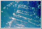
 Jet Stream Cirrus, Saudi Arabia
This series of cirrus clouds is know as "roll clouds" because
they are sculpted into tight rolls by air currents from the jet stream
over Saudi Arabia and the Red Sea. The crest-to-crest spacing of the cloud
bands can be used to calculate the velocity of the jet stream.
(Courtesy LPI/NASA. Picture #13-32-1159)
 Jet Stream Convergence
This photograph taken over Namibia reveals another effect of jet
streams. Here two streams converge; cloud has formed in the corridor
between the two streams. Turbulence along the margins of the jet stream
may explain the sharp boundary. The point of convergence of the two air
streams is precisely located by this photograph. Shadows mark the cloud
edges against a sunlit Namibian backdrop.
(Courtesy LPI/NASA. Picture #13-31-092)
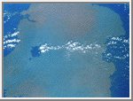
 Cloud Streets, Tiladumati Atoll, Maldive Islands
Small cumulus clouds frequently form in parallel rows or "cloud
streets" in stable air conditions. These cloud streets over the reefs
of the Maldive Islands in the Indian Ocean denote the prevailing wind
direction, the cloud streets lying parallel with the wind. Turbulent
air lifted by the windward portions of the islands promotes cloud
formation downwind.
(Courtesy LPI/NASA. Picture #13-35-1459)
 Island Wake, Hawaii
The combination of warm water temperature and hundreds of square miles of
ocean, uninterrupted by land masses, results in a regular cumulus and
stratocumulus cloud formation. In the Pacific Ocean the Trade Winds propel
the clouds from east to west across the ocean. When the air current is
intercepted by a sufficiently high land mass, such as the Big Island of
Hawaii, the stable cloud pattern is interrupted and the clouds divide to
bypass the island in a wide arc forming an "island wake." In
addition to illustrating how gracefully the clouds circumnavigate Hawaii's
volcanic peaks, the photograph shows how the prevailing wind direction
dictates that the north and northeast of the island are wetter than the
western side of the island and frequently under cloud. The clouds deposit
rain on the low ground before dividing and spinning out to sea when they
meet the Kohala Mountains and Mauna Kea with its summit at 4,205 meters
(13,796 feet).
(Courtesy LPI/NASA. Picture #25-47-016)
 Cloud Tail, Lake Tana
Islands or high land, elevated above the surroundings and interrupting the
air stream, can produce "tails" as well as "wakes."
Shuttle astronauts have frequently observed Dek Island in Lake Tana in
Ethiopia, the source of the Blue Nile, with a well-developed cloud tail.
This occurs when the land mass disrupts the air flow, creating downwind
turbulence that promotes condensation. The lake stands at 1,800 meters
(6,000 feet) above sea level.
(Courtesy LPI/NASA. Picture #27-38-003)
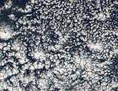 Open Cells Over The Ocean
What atmospheric scientists refer to as open cell cloud formation is a regular
occurrence on the back side of a low pressure system or cyclone in the mid-latitudes.
In the northern hemisphere, a low-pressure system will draw in surrounding air and
spin it counterclockwise. That means that on the back side of the low pressure center,
cold air will be drawn in from the north, and on the front side, warm air will be
drawn up from latitudes closer to the equator. This movement of an air mass is called
advection, and when cold air advection occurs over warmer waters, open cell cloud
formations often result.
This image shows open cell cloud formation over the Atlantic Ocean off the
southeast coast of the United States. This particular formation
is the result of a low-pressure system sitting out in the North Atlantic Ocean a few
hundred miles east of Massachusetts. Cold air is being drawn down
from the north on the western side of the low and the open cell cumulus clouds begin
to form as the cold air passes over the warmer Caribbean waters.
(Courtesy NASA/GSFC)
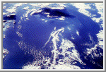
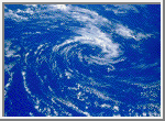 Anticyclonic Clouds
This pinwheel of anticyclonic clouds was photographed by the STS 41-B crew
over the southern hemisphere of the Pacific Ocean. The ground winds at
the center of this cyclonic system reach 80 kilometers per hour (50 miles an hour).
Circular storms in the northern hemisphere produce spiraling clouds
with a clockwise pattern, while southern latitude storms have a
counterclockwise cloud motion.
(Courtesy LPI/NASA. Picture #11-45-2834)
 Eye of Hurricane Kamysi
During the Solar Maximum Satellite Repair Mission, astronauts had an
excellent opportunity to look down the eye of Hurricane Kamysi over the
Indian Ocean. Clear blue water can be seen through the hurricane's eye,
and the crew reported that they could see the ocean wave below.
Unfortunately, the camera film could not pick them out.
(Courtesy LPI/NASA. Picture #13-35-1499)
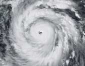
Super Typhoon Jangmi
Seen from space, even a super typhoon seems more beautiful than dangerous. The
50-kilometer-wide eye of Jangmi is encircled by a smooth disk of clouds. Bands
of clouds swirl gracefully into the low-pressure heart of the storm. The smooth
cloud band north of the eye is studded with thunderstorms. The eye is
tightly formed. The tighter the eye in a circular storm, the stronger
the winds underneath.
On the ground, Jangmi was less lovely. It came ashore on northeastern Taiwan
(pictured at upper left of the image) as a Category 4 typhoon, and torrential
rains led to floods and landslides. With maximum sustained winds of 260
kilometers per hour (162 mph), Jangmi was not only the strongest storm in any
ocean basin in 2008, it was also the only storm to reach Category 5 strength
anywhere in the world that year.
(Courtesy NASA)
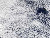 Vortex Street Near Madeira Island
A vortex street streams slightly southeast of the Ilha da Madeira
(Madeira Island) in this true-color Terra MODIS image acquired December
1, 2002. A vortex street forms when clouds over the ocean are disturbed
by winds passing over land or other above-sea-surface obstacles, in
this case the Ilha da Madeira. The southeastern movement of the
low-level winds caused the clouds to line up in the same direction,
called a street, and the wind's passage over the islands caused the
swirls, called vortices.
The particular kind of clouds forming the vortex street is referred to as
"closed cell". These cells, or parcels of air, often occur in roughly
hexagonal arrays in a layer of air that behaves like a fluid (as often
occurs in the atmosphere) and begins to convect due to heating at the
base or cooling at the top. In these closed cell clouds, warm air is
rising at their centers and sinking around the edges to create this
honeycomb-like pattern.
(Courtesy GSFC/NASA)
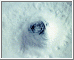
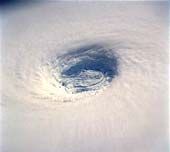 Eye of Typhoon Yuri
This spectacular, low-oblique photograph shows the bowl-shaped
eye (center of photograph) of Typhoon Yuri in the western
Pacific Ocean just west of the Northern Mariana Islands. The
eye wall descends almost to the sea surface, a distance of
nearly 45,000 feet (13,800 meters). In this case the eye is
filled with clouds, but in many cases the sea surface can be
seen through the eye. Yuri grew to super typhoon status,
packing maximum sustained winds estimated at 165 miles (270
kilometers) per hour, with gusts reaching an estimated 200
miles (320 kilometers) per hour. The storm moved west toward
the Philippine Islands before turning northeast into the north
Pacific Ocean, thus avoiding any major landmass.
(Courtesy NASA)
 Weather System Margin
The Discovery crew photographed this very distinct stripe running through
the clouds for several hundred miles. Two weather systems are sliding past
each other like crustal plates on the Earth's surface. The one at the top of
the photograph (geographical north) is moving up and curing away slightly
to the north, while the system at the bottom of the frame is moving
westward and curving gently to the south in conjunction with a cyclone
located several hundred miles away. The miniature cold-water gyres on the
fringes of the two weather systems indicate that a channel of colder water
runs under the break in the clouds and is reflected above where colder air
runs between the two cloud masses.
(Courtesy LPI/NASA. Picture #25-31-011)
This material was abstracted from the slide set:
Jones, Pat. Shuttle Views the Earth - Clouds from Space. Planetary Image Center/Lunar & Planetary Institute.

 Earth
Earth