My view of our planet was a glimpse of divinity.
-Edgar Mitchell, USA
|
Table of Contents |
|
Earth Introduction
|
|
Earth's Moon |
|
Earth Science |
|
Internet Resources |
From the perspective we get on Earth, our planet appears to be big and sturdy with an endless ocean of air. From space, astronauts often get the impression that the Earth is small with a thin, fragile layer of atmosphere. For a space traveler, the distinguishing Earth features are the blue waters, brown and green land masses and white clouds set against a black background.
Many dream of traveling in space and viewing the wonders of the universe. In reality all of us are space travelers. Our spaceship is the planet Earth, traveling at the speed of 108,000 kilometers (67,000 miles) an hour.
Earth is the 3rd planet from the Sun at a distance of about 150 million kilometers (93.2 million miles). It takes 365.256 days for the Earth to travel around the Sun and 23.9345 hours for the Earth rotate a complete revolution. It has a diameter of 12,756 kilometers (7,973 miles), only a few hundred kilometers larger than that of Venus. Our atmosphere is composed of 78 percent nitrogen, 21 percent oxygen and 1 percent other constituents.
Earth is the only planet in the solar system known to harbor life. Our planet's rapid spin and molten nickel-iron core give rise to an extensive magnetic field, which, along with the atmosphere, shields us from nearly all of the harmful radiation coming from the Sun and other stars. Earth's atmosphere protects us from meteors, most of which burn up before they can strike the surface.
From our journeys into space, we have learned much about our home planet. The first American satellite, Explorer 1, discovered an intense radiation zone, now called the Van Allen radiation belts. This layer is formed from rapidly moving charged particles that are trapped by the Earth's magnetic field in a doughnut-shaped region surrounding the equator. Other findings from satellites show that our planet's magnetic field is distorted into a tear-drop shape by the solar wind. We also now know that our wispy upper atmosphere, once believed calm and uneventful, seethes with activity -- swelling by day and contracting by night. Affected by changes in solar activity, the upper atmosphere contributes to weather and climate on Earth.
Besides affecting Earth's weather, solar activity gives rise to a dramatic visual phenomenon in our atmosphere. When charged particles from the solar wind become trapped in Earth's magnetic field, they collide with air molecules above our planet's magnetic poles. These air molecules then begin to glow and are known as the auroras or the northern and southern lights.
| Earth Statistics | |
|---|---|
| Mass (kg) | 5.976e+24 |
| Mass (Earth = 1) | 1.0000e+00 |
| Equatorial radius (km) | 6,378.14 |
| Equatorial radius (Earth = 1) | 1.0000e+00 |
| Mean density (gm/cm^3) | 5.515 |
| Mean distance from the Sun (km) | 149,600,000 |
| Mean distance from the Sun (Earth = 1) | 1.0000 |
| Rotational period (days) | 0.99727 |
| Rotational period (hours) | 23.9345 |
| Orbital period (days) | 365.256 |
| Mean orbital velocity (km/sec) | 29.79 |
| Orbital eccentricity | 0.0167 |
| Tilt of axis (degrees) | 23.45 |
| Orbital inclination (degrees) | 0.000 |
| Equatorial escape velocity (km/sec) | 11.18 |
| Equatorial surface gravity (m/sec^2) | 9.78 |
| Visual geometric albedo | 0.37 |
| Mean surface temperature | 15°C |
| Atmospheric pressure (bars) | 1.013 |
| Atmospheric composition
Nitrogen
Oxygen Other | 77% 21% 2% |
- Rotation Earth Movie.
- Earth's Lights at Night.
- Earth Topography Animation.
- Aurora Video.
- Earth/Venus Rotation Movie.
- Galileo Earth Encounter.
- Earth: The Movie - Animation of Clouds & Flight.
- Earth: The Movie - Animation of Clouds.
The following set of images show some of the wonders of our planet, the Earth.
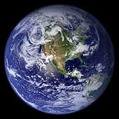
Blue Marble West
This spectacular "blue marble" image is the most detailed
true-color image of the entire Earth to date. Using a
collection of satellite-based observations, scientists and
visualizers stitched together months of observations of the
land surface, oceans, sea ice, and clouds into a seamless,
true-color mosaic of every square kilometer (.386 square
mile) of our planet.
(Courtesy NASA/MODIS/USGS)
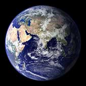 Blue Marble East
This spectacular "blue marble" image is the most detailed
true-color image of the entire Earth to date. Using a
collection of satellite-based observations, scientists and
visualizers stitched together months of observations of the
land surface, oceans, sea ice, and clouds into a seamless,
true-color mosaic of every square kilometer (.386 square
mile) of our planet.
(Courtesy NASA/MODIS/USGS)
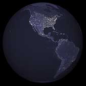 Earth Lights of North and South America
This image of North and South America city lights was created with data
from the Defense Meteorological Satellite Program (DMSP) Operational
Linescan System (OLS). Originally designed to view clouds by moonlight,
the OLS is also used to map the locations of permanent lights on the
Earth's surface.
The brightest areas of the Earth are the most urbanized, but not
necessarily the most populated. Cities tend to grow along coastlines
and transportation networks. Even without the underlying map,
the outlines of the continents are still be visible. The United
States interstate highway system appears as a lattice connecting the
brighter dots of city centers.
(Copyright Calvin J. Hamilton)
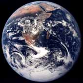 Africa
The crew of Apollo 17 took this photograph of Earth in December 1972 while
the spacecraft was traveling between the Earth and the Moon. The orange-red
deserts of Africa and Saudi Arabia stand in stark contrast to the deep blue
of the oceans and the white of both clouds and snow-covered Antarctica.
(Courtesy NASA)
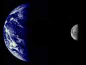 Mariner 10's View of the Earth & Moon
The Earth and Moon were imaged by Mariner 10
from 2.6 million kilometers while completing the first ever Earth-Moon
encounter by a spacecraft capable of returning high resolution digital
color image data. These images have been combined below to illustrate
the relative sizes of the two bodies. From this particular viewpoint
the Earth appears to be a water planet!
(Courtesy NASA/JPL/Northwestern University)
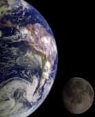 The Earth & Moon
During its flight, the Galileo spacecraft returned
images of the Earth and Moon. Separate images of the Earth and Moon were
combined to generate this view. The Galileo spacecraft took the images in
1992 on its way to explore the Jupiter system in 1995-97. The image shows
a partial view of the Earth centered on the Pacific Ocean about latitude
20 degrees south. The west coast of South America can be observed as well
as the Caribbean; swirling white cloud patterns indicate storms in the
southeast Pacific. The distinct bright ray crater at the bottom of the
Moon is the Tycho impact basin. The lunar dark areas are lava rock filled
impact basins. This picture contains same scale and relative color/albedo
images of the Earth and Moon.
(Courtesy USGS/NASA)
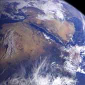 Northeast Africa and the Arabian Peninsula
This image of northeast Africa and the Arabian
Peninsula was taken from an altitude of about 500,000 kilometers (300,000
miles) by the Galileo spacecraft on December 9, 1992, as it left Earth en
route to Jupiter. Visible are most of Egypt (left of center), including
the Nile Valley; the Red Sea (slightly above center); Israel; Jordan, and
the Arabian Peninsula. In the center, below the coastal cloud, is
Khartoum, at the confluence of the Blue Nile and the White Nile. Somalia
(lower right) is partly covered by clouds.
(Courtesy NASA/JPL)
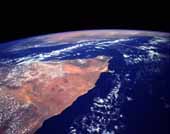 Horn of Africa, Somalia
The orange and tan colors of this high-oblique photograph of
the Horn of Africa indicate an arid-to-semiarid landscape in
the northern half of the east African country of Somalia.
Except in the darker areas where thicker vegetation can be
found, most of the vegetation
in this part of Somalia is shrub brush and grasslands.
The general climate of this
region features hot temperatures and scarce, irregular
rainfall. Two distinct drainage basins are characterized
by lighter colors-the Nugaaleed Valley along the western
side of the photograph and the other watershed trending
toward the Hafun Peninsula, the tombolo along the east
coast of Somalia. The southern extent of the Saudi Arabian
Peninsula is visible north across the Gulf of Aden.
(Courtesy NASA)
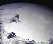
 Southern Tip of Greenland
The southern tip of Greenland is seen in this high-oblique, almost
colorless, stark photograph of the world's largest island. The
blackness of space contrasts sharply with the whiteness of clouds,
ice, and snow. The only true color is the blue of the Atlantic
Ocean and the Labrador Sea. Cloud-free conditions existing along
the southern coastal area emphasize the deeply indented fjords
along the coast. A close look at the white areas reveals three
different features-snow and ice on the land; cloud formations over
the central region and the eastern and western sides of the island;
and wispy-looking ice floes off the southeast and the southwest tip
of the fjord-lined coast, which are moved by the East Greenland
Current to the south-southwest, and larger ice packs developing
north along the east coast. Greenland has the only surviving
continental glacier in the Northern Hemisphere. This ice sheet
covers seven-eighths of Greenland's surface and contains an
estimated 11 percent of the world's fresh water.
(Courtesy NASA)
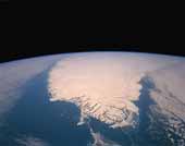
 Antarctica
This image of Antarctica was taken by Galileo several hours
after it flew close to the Earth
on December 8, 1990. This is the first picture of the whole Antarctic
continent taken nearly at once from space.
Galileo was about 200,000 kilometers (125,000
miles) from Earth when the pictures were taken.
The icy continent is surrounded by the dark blue of three
oceans: the Pacific to the left, the Indian to the bottom, and a piece of the
Atlantic to the upper right. Nearly the entire continent was sunlit at
this time of year, just two weeks before southern summer solstice. The
arc of dark spots extending from near the South Pole (close to the center)
toward the lower left is the Transantarctic Mountain Range. To the
left of the mountains is the vast Ross Ice Shelf and the shelf's sharp
border with the dark waters of the Ross Sea. The thin blue line along the
Earth's limb
marks our planet's atmosphere. (Courtesy NASA/JPL)
 Clementine Mission
This false-colored image was acquired during the Clementine mission.
It shows airglow of the upper atmosphere as a thin blue line. The
bright spot toward the bottom is an urban area.
(Courtesy Naval Research Laboratory)
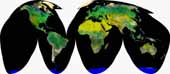 Map projected image of Earth (AVHRR)
This image is a Homolosine projection of the Earth prepared from
Advanced Very High Resolution Radiometer (AVHRR) image data.
(Courtesy ESA/NASA/NOAA/USGS/CSIRO)
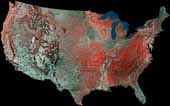 USA
USA
This image is a mosaic of the United States prepared by using 16
images from the Advanced Very High Resolution Radiometer (AVHRR) sensors
on the meteorological satellites NOAA-8 and NOAA-9. The images were
acquired between May 24, 1984 and May 14, 1986.
On false-color infrared mosaics, vegetation appears in various tones
of red instead of green. The "redness" indicates vegetation density,
type and whether growing on dry land or in a swamp (a mixture of reddish
vegetation and dark blue surface water produces dark tones). Grasslands
appear light red, deciduous trees and croplands appear red, and
coniferous forests appear dark red or maroon. Desert areas appear white
and urban areas (pavement and buildings) appear bluish green. Lakes,
rivers and oceans appear in various shades of blue, dark blue for deep
water and light blue for shallow or turbid water. Exposed bedrock
generally appears as a dark bluish-green or other dark tone.
(Courtesy USGS)

 Return to Venus
 Voyage to Mars