Saturn IV
Dione [dy-OH-nee] was discovered in 1684 by Giovanni Cassini. It is an icy body similar to Tethys and Rhea. Its density is 1.43 gm/cm3, which makes it the densest moon of Saturn other than Titan. Dione is probably composed of a rocky core making up one-third of the moon's mass, with the rest water-ice. Its ice coverage is less than that of Tethys and Rhea.
Dione's icy surface includes heavily cratered terrain, moderately cratered plains, lightly cratered plains, and wispy material. The heavily cratered terrain has numerous craters greater than 100 kilometers in diameter. The plains area tends to have craters less than 30 kilometers in diameter. Some of the plains are heavily cratered while others are not. Much of the heavily cratered terrain is located on the trailing hemisphere, with the less cratered plains area existing on the leading hemisphere. This is opposite from what some scientists expected. Shoemaker and Wolfe proposed a cratering model for a tidally locked satellite with the highest cratering rates on the leading hemisphere and the lowest on the trailing hemisphere. This suggests that during the period of heavy bombardment, Dione was tidally locked to Saturn in the opposite orientation. Because Dione is relatively small, an impact causing a 35 kilometer (21 mile) crater could have spun the satellite. Since there are many craters larger than 35 kilometers (21 miles), Dione could have been repeatedly spun.
Dione has probably been tidally locked in its current position for the past several billion years. This is reflected in the average surface albedo of the leading and trailing hemispheres. The surface albedo decreases from the leading to the trailing hemispheres due to a higher micrometeor dusting on the leading hemisphere.
The origin of the bright wispy material is somewhat obscure. Apparently, it is material with a high albedo and is thin enough that it doesn't obscure the surface feature underneath. It might have formed from eruptions along cracks in Dione's surface that fell back to the surface as snow or ash.
| Dione Statistics | |
|---|---|
| Discovered by | Giovanni Domenico Cassini |
| Date of discovery | 1684 |
| Mass (kg) | 1.05e+21 |
| Mass (Earth = 1) | 1.7570e-04 |
| Equatorial radius (km) | 560 |
| Equatorial radius (Earth = 1) | 8.7802e-02 |
| Mean density (gm/cm^3) | 1.43 |
| Mean distance from Saturn (km) | 377,400 |
| Rotational period (days) | 2.736915 |
| Orbital period (days) | 2.736915 |
| Mean orbital velocity (km/sec) | 10.03 |
| Orbital eccentricity | 0.0022 |
| Orbital inclination (degrees) | 0.02 |
| Escape velocity (km/sec) | 0.500 |
| Surface gravity (m/sec^2) | 0.223 |
| Visual geometric albedo | 0.7 |
| Magnitude (Vo) | 10.4 |
| Mean surface temperature | -186.56°C |
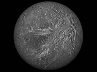 Animation of Saturn's Moon Dione
This animation of Saturn's moon Dione was created from a global map
created using images taken during flybys by NASA's Cassini spacecraft.
Images from NASA's Voyager mission fill the gaps in Cassini's coverage.
An extensive system of bright ice cliffs created by tectonic fractures
adorns the moon's trailing hemisphere.
(Copyright Calvin J. Hamilton)
 Dione
Dione
This image of Dione is a mosaic of several of the highest resolution
images taken by the Voyager spacecraft. It shows a heavily cratered
surface. The large crater named Aeneas, towards the top
of this image, is 150 kilometers (90 miles) in diameter.
Another large crater named Dido, towards the bottom, is
125 kilometers (75 miles) in diameter.
Bright streaks are found on the opposite side of Dione. A rimmed and
flat floored fracture near the terminator is named Latium Chasma.
It is greater than 300 kilometers (180 miles) long, less than
1 kilometer (.6 miles) deep and 8 to 12 kilometers (4.8 to 7.2 miles) wide.
(Copyright Calvin J. Hamilton)
 Dione in Full View
The cratered and cracked disk of Saturn's moon Dione looms ahead in this
mosaic of images taken by Cassini on Oct.11, 2005, as it neared its close
encounter with the icy moon.
The images used for this mosaic are clear-filter views, which reveal a great deal of surface detail.
Multiple generations of tectonics can be seen in this full-disk view. Near the eastern limb (at the right) are tectonic fractures, which may be similar to the bright, braided canyons that make up Dione's noted wispy terrain. Some of the bright, wispy markings can be seen at the left.
The softer ridges and troughs at the upper right appear to be about the same age as the cratering seen in that region. These appear to be older than the fracturing seen in the wispy terrain and the fractures seen at the right.
Scientists continue to be intrigued by the strikingly linear features seen crisscrossing the southern latitudes. The fine latitudinal streaks appear to crosscut everything, and appear to be the youngest feature type in this region of Dione.
A large impact basin hugs the south polar region (at the bottom, right of center). Northeast of the basin is a region of terrain that is relatively smooth, compared to the rest of the moon.
This view of Dione is centered on 1.3 degrees south latitude, 167.6
degrees west longitude. For a false-color view see PIA07747.
(Courtesy NASA/JPL/Space Science Institute)
 Dione in Full View - False Color
The cratered and cracked disk of Saturn's moon Dione looms ahead in this
mosaic of images taken by Cassini on Oct. 11, 2005, as it neared its close
encounter with the icy moon.
In this false-color mosaic, the clear-filter images are overlain by color composited from (compressed) infrared, green and ultraviolet images. The colors have been specially processed to accentuate subtle changes in the spectral properties of Dione's surface materials.
To create the color view, the color images were combined into a single black and white picture that isolates and maps regional color differences. This "color map" was then superimposed over the clear-filter mosaic. Gaps in the imaging coverage appear black.
Multiple generations of tectonics can be seen in this full-disk view. Near the eastern limb (at the right) are tectonic fractures, which may be similar to the bright, braided canyons that make up Dione's noted wispy terrain. Some of the bright, wispy markings can be seen at the left.
The softer ridges and troughs at the upper right appear to be about the same age as the cratering seen in that region. These appear to be older than the fracturing seen in the wispy terrain and the fractures seen at the right.
Scientists continue to be intrigued by the strikingly linear features seen crisscrossing the southern latitudes. The fine latitudinal streaks appear to crosscut everything, and appear to be the youngest feature type in this region of Dione.
A large impact basin hugs the south polar region (at the bottom, right of
center). Northeast of the basin is a region of terrain that is relatively
smooth, compared to the rest of the moon.
(Courtesy NASA/JPL/Space Science Institute)
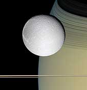 Ringside with Dione
Speeding toward pale, icy Dione, Cassini's view is enriched by the
tranquil gold and blue hues of Saturn in the distance. The horizontal
stripes near the bottom of the image are Saturn's rings. The spacecraft
was nearly in the plane of the rings when the images were taken, thinning
them by perspective and masking their awesome scale. The thin, curving
shadows of the C ring and part of the B ring adorn the northern latitudes
visible here, a reminder of the rings' grandeur.
It is notable that Dione, like most of the other icy Saturnian satellites,
looks no different in natural color than in monochrome images.
(Courtesy NASA/JPL/Space Science Institute)
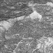 In the Groove
The Cassini spacecraft continues to prove that the closer the view of the
myriad worlds constituting the Saturn system, the more interesting and
varied the views become. This close-up view of icy Dione reveals a
wonderful variety of surface features that are simultaneously familiar
and unlike any other place in the solar system.
The terrain in this image is located within a 60-kilometer-wide (37-mile) impact crater along the feature called Padua Linea. The western rim of the encompassing crater runs from the middle left to the upper right. The crater's central peak can be seen at the lower right.
Multiple generations of fractures are visible here. Numerous fine, roughly parallel linear grooves run across the terrain from top to bottom and are interrupted by the larger, irregular bright fractures. In several places, fractures postdate some deposits in the bottoms of craters that are not badly degraded by time. Such a fracture, for example, runs from the center toward the upper right.
Most of the craters seen here have bright walls and dark deposits of material on their floors. As on other Saturnian moons, rockslides on Dione may reveal cleaner ice, while the darker materials accumulate in areas of lower topography and lower slope (e.g. crater floors and the bases of scarps).
This view is centered on terrain near 11 degrees south latitude, 238
degrees west longitude.
(Courtesy NASA/JPL/Space Science Institute)
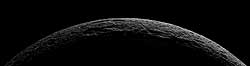 Icy Crescent
As it departed its encounter with Saturn's moon Dione, Cassini sailed
above an unreal landscape blasted by impacts. The rising Sun throws
craters into sharp contrast and reveals steep crater walls.
At the far right, a medium-sized crater is bisected by a fracture, revealing a cross section of the impact site.
The seven clear-filter images in this mosaic were taken with the Cassini
spacecraft narrow-angle camera on Oct. 11, 2005, at distances ranging from
of 21,650 to 25,580 kilometers (13,450 to 15,890 miles) from Dione and at
a Sun-Dione-spacecraft, or phase, angle of 154 degrees. Resolution in the
original images ranges from 126 to 154 meters (413 to 505 feet) per pixel.
The images have been re-sized to have an image scale of about 100 meters
(330 feet) per pixel. North on Dione is 140 degrees to the left.
(Courtesy NASA/JPL/Space Science Institute)
 Pair to Compare
Saturn's moon Dione occults part of Saturn's distant rings while Tethys
hovers below. Dione is 1,118 kilometers (695 miles) across, while Tethys
is 1,071 kilometers, 665 miles) across.
This image offers excellent contrast with a previously released view (see PIA06629) that showed the bright, wispy markings on Dione's trailing hemisphere. The huge impact structure Odysseus (450 kilometers, or 280 miles across) is near the limb of Tethys. Compared with the battered surface of Tethys, Dione appears much smoother from this distance.
The image was taken in visible light with the Cassini spacecraft
narrow-angle camera on March 19, 2005, at a distance of approximately
2.7 million kilometers (1.7 million miles) from Saturn. The image scale
is approximately 15 kilometers (9 miles) per pixel.
(Courtesy NASA/JPL/Space Science Institute)
 Crisscrossing Streaks
A gorgeous Dione poses for Cassini, with shadowed craters and bright,
wispy streaks first observed by the Voyager spacecraft 24 years ago. The
wispy areas will be imaged at higher resolution in mid-December 2004.
Subtle variations in brightness across the surface of this moon are
visible here as well. Dione's diameter is 1,118 kilometers, (695 miles).
The image shows primarily the trailing hemisphere of Dione, which is the side opposite the moon's direction of motion in its orbit. The image has been rotated so that north is up.
The image was taken in visible light with the Cassini spacecraft narrow
angle camera on Oct. 27, 2004, at a distance of about 1.2 million
kilometers (746,000 miles) from Dione and at a Sun-Dione-spacecraft, or
phase, angle of 28 degrees. The image scale is 3.5 kilometers (2.2 miles)
per pixel.
(Courtesy NASA/JPL/Space Science Institute)
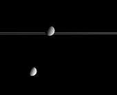
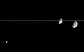 Amazing Icy Moons
A scene straight out of science fiction, this fantastic view shows, from
left to right, Saturn's moon's Mimas, Dione and Rhea, on the far side of
Saturn's nearly edge-on rings.
The trailing hemispheres of all three moons are sunlit here, and wispy
markings can be seen on the limbs of both Dione and Rhea. The diameter of
Mimas is 397 kilometers (247 miles), Dione is 1,118 kilometers (695 miles)
and Rhea is 1,528 kilometers (949 miles).
(Courtesy NASA/JPL/Space Science Institute)
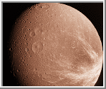
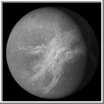
 Color Composite
This image is a color composite of Dione taken by
Voyager 1 on November 12, 1980.
It was constructed from three
separate images taken through orange, green and blue filters.
It shows a low resolution view of the trailing hemisphere of Dione.
The wispy white streaks are perhaps deposits of snow exuded from
fractures in its crust.
(Copyright Calvin J. Hamilton)
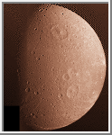
Wispy White Streaks
This image of Dione was taken by
Voyager 1 on November 12, 1980.
It shows the Saturn-facing hemisphere. The darker trailing hemisphere
is located toward the right limb, with wispy white streaks
crisscrossing the surface. The plains terrain is located along
the terminator.
(Copyright Calvin J. Hamilton)
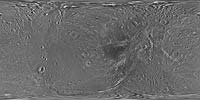 Map of Dione - October 2010
This global map of Saturn's moon Dione was created using images taken during flybys by NASA's Cassini spacecraft. Images from NASA's Voyager mission fill the gaps in Cassini's coverage.
An extensive system of bright ice cliffs created by tectonic fractures adorns the moon's trailing hemisphere, which is centered on 270 degrees west.
The map is a simple cylindrical (equidistant) projection and has a scale of 153 meters (500 feet) per pixel at the equator. The resolution of the map is 64 pixels per degree. The mean radius of Dione used for projection of this map is 563 kilometers (350 miles).
This map is an update to the version released in February 2010 (see PIA12577). The title of that older version ("Map of Dione - February 2010") denotes the month the map was released, not when the data in the map were collected. The title of this new version reflects when the most recent data used in the map were captured.
The newest data were used to improve coverage across the whole north polar region. Moving south from the north polar region, coverage is improved all the way down to about 45 degrees south latitude in the area between the leading hemisphere and the anti-Saturn side of the moon from about 95 degrees west longitude to 135 degrees west longitude. Even farther south, new coverage on the trailing hemisphere reaches to about 65 degrees south latitude from about 220 degrees west longitude to 360 degrees west longitude.
Like other recent Dione global maps, this map has been shifted west by 0.6 degrees of longitude, compared to the 2006 version of the map (PIA08341), in order to conform to the International Astronomical Union longitude system convention for Dione.
(Courtesy NASA/JPL/Space Science Institute)
 Orthographic Projection of Dione
This image was created by projecting a digital map of Dione onto an orthographic view.
It includes Longitude and latitude lines to give it a strong 3D feel.
(Courtesy A.Tayfun Oner)
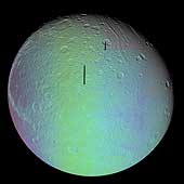
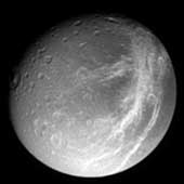
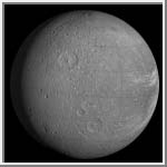
 Trailing Hemisphere of Dione
One of the most striking features of Dione is the bright wispy terrain
on the trailing hemisphere. Most of these wisps are radial to the large
crater Amata but they are curvilinear and do not resemble crater rays.
Some of them are associated with topographic features and this suggests
that they are surface deposits of ice outgassed from a global tectonic
system of fractures.
(Courtesy A. Tayfun Oner)
Boyce, J. M. and J. B. Plescia. "Crater densities and geological histories of Rhea, Dione, Mimas and Tethys." Nature, 295, 285-289, 1982.
Moore, Jeffrey M. "The Tectonic and Volcanic History of Dione." ICARUS, 59, 205-220, 1984.
Plescia, J. B. "The Geology of Dione." ICARUS, 56, 255-277, 1983.
Soderblom, Laurence A. and Torrence V. Johnson. "The Moons of Saturn." Scientific American, January 1982.

 Saturn
 Telesto
 Helene