Saturn III
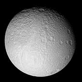
Tethys [TEE-this] was discovered by Giovanni Cassini in 1684. It is an icy body similar in nature to Dione and Rhea. The density of Tethys is 1.21 gm/cm3, indicating that it is composed almost entirely of water-ice. Tethys's icy surface is heavily cratered and contains cracks caused by faults in the ice. The terrain is composed of densely cratered regions with a lightly cratered, dark belt that extends across the satellite. Light cratering indicates that Tethys was once internally active, causing parts of the older terrain to be resurfaced. The exact cause for the dark belt is unknown, but a possible interpretation comes from recent Galileo images of Jupiter's moons Ganymede and Callisto. Both satellites exhibit light polar caps that are made from bright ice deposits on pole-facing slopes of craters. From a distance the caps appear brighter due to a haze caused by thousands of unresolved ice patches in small craters. Tethys' surface may have been formed in a similar manner, consisting of hazy polar caps of unresolved bright ice patches with a darker zone in-between.
Tethys has an enormous trench named Ithaca Chasma that is about 65 kilometers (40 miles) wide and several kilometers deep. It covers three-fourths of Tethys' circumference. The fissure is about the size scientists would predict if Tethys were once fluid and its crust hardened before the interior. Another prominent feature is an enormous 400-kilometer impact basin named Odysseus. The impact scar spans more than two-fifths of the satellite with a diameter slightly larger than Saturn's moon Mimas. When Odysseus was first created, the crater must have been deep with a high mountainous rim and towering central peak. Over time the crater floor relaxed to the spherical shape of the Tethys's surface, and the crater's rim and central peak collapsed. Tethys' surface temperature is -187° C (-305° F).
| Tethys Statistics | |
|---|---|
| Discovered by | Giovanni Domenico Cassini |
| Date of discovery | 1684 |
| Mass (kg) | 7.55e+20 |
| Mass (Earth = 1) | 1.2634e-04 |
| Equatorial radius (km) | 530 |
| Equatorial radius (Earth = 1) | 8.3098e-02 |
| Mean density (gm/cm^3) | 1.21 |
| Mean distance from Saturn (km) | 294,660 |
| Rotational period (days) | 1.887802 |
| Orbital period (days) | 1.887802 |
| Mean orbital velocity (km/sec) | 11.36 |
| Orbital eccentricity | 0.0000 |
| Orbital inclination (degrees) | 1.09 |
| Escape velocity (km/sec) | 0.436 |
| Visual geometric albedo | 0.9 |
| Magnitude (Vo) | 10.2 |
| Mean surface temperature | -187°C |
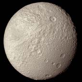
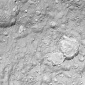
Tethys
This view of Tethys was taken by Voyager 2 on August 26, 1981
from a range of 282,000 kilometers (175,000 miles).
It is the best complete image acquired by the Voyager
spacecraft. An enormous trench named Ithaca Chasma
extends from the left side of this image to the upper center.
The fissure is about 65 kilometers (40 miles) wide,
several kilometers deep, and extends across three-fourths
of Tethys' circumference.
The image also shows two types of terrain one of which is
heavily cratered (top) and the other more lightly cratered (bottom).
Both of Saturn's moons Dione
and Rhea exhibit similar boundaries.
Light cratering indicates that the region was once internally active,
causing partial resurfacing of older terrain.
(Copyright Calvin J. Hamilton)
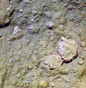
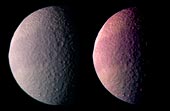 Color Image reveals a Dark Belt on Tethys
This is the best color image of Tethys taken by the Voyager 1 spacecraft.
It was produced by combining three images taken through orange, green
and blue filters. The image on the right has been color and contrast
enhanced in order to emphasize the dark belt that stretches across
the satellite.
The exact cause for the dark band is unknown, but a possible interpretation comes from recent Galileo images of Jupiter's moons Ganymede and Callisto. Both satellites exhibit light polar caps that are made from bright ice deposits on pole-facing slopes of craters. From a distance the caps appear brighter due to a haze caused by thousands of unresolved patches of ice in small craters. The dark band on Tethys may have been formed in a similar manner, consisting of hazy polar caps of unresolved bright ice patches with a dark zone in-between.
Another notable feature is the bright terrain
along the limb in the upper left-hand corner of the image.
This is a cross section through the giant Odysseus impact basin
and shows the fact that the crater must have been formed at a time
when the ice was still relative warm and soft. The crater no longer
shows deep bowl shape characteristics of craters formed in cold ice or rock.
(Copyright Calvin J. Hamilton)
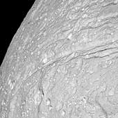 Steep Scarps
This view of the surface of Saturn's moon Tethys, taken during Cassini's
close approach to the moon on Sept. 24, 2005, reveals an icy land of steep
cliffs. The view is of the southernmost extent of Ithaca Chasma, in a
region not seen by NASA's Voyager spacecraft.
The ridges around Ithaca Chasma have been thoroughly hammered by impacts. This appearance suggests that Ithaca Chasma as a whole is very old.
There is brighter material in the floors of many craters on Tethys. That's the opposite situation from Saturn's oddly tumbling moon Hyperion, where dark material is concentrated in the bottoms of many craters.
This view is centered on terrain at approximately 2.5 degrees south latitude and 352 degrees west longitude on Tethys. North on Tethys is toward the right in this view.
This clear filter view was obtained using the Cassini spacecraft
narrow-angle camera at a distance of approximately 32,300 kilometers
(20,000 miles) from Tethys and at a Sun-Tethys-spacecraft, or phase,
angle of 20 degrees. Image scale is 190 meters (620 feet) per pixel.
(Courtesy NASA/JPL/Space Science Institute)
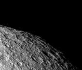
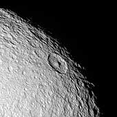 Old Northern Terrains
The northern polar region of Saturn's moon Tethys seen in this Cassini
flyby image is a ponderously ancient surface.
Above the prominent peaked crater Telemachus are the remnants of a very old crater (at the 10 o'clock position relative to Telemachus) named Teiresias. The ancient impact site is so badly overprinted and eroded by impact weathering and degradation that all that remains is a circular pattern of hummocks that mark where the old crater rim existed.
This view is centered on terrain at approximately 1.2 degrees south latitude and 342 degrees west longitude on Tethys. The view is rotated so that north is about 40 degrees to the right.
This clear filter view was taken during Cassini's close approach to
Tethys on Sept. 24, 2005. The image was acquired using the Cassini
spacecraft narrow-angle camera at a distance of approximately 69,200
kilometers (43,000 miles) from Tethys and at a Sun-Tethys-spacecraft, or
phase, angle of 21 degrees. Image scale is 410 meters (1,350 feet) per
pixel.
(Courtesy NASA/JPL/Space Science Institute)
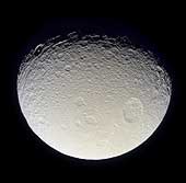
 "Hi-Res" on Tethys
This view is among the closest Cassini images of Tethys' icy surface taken
during the Sept. 24, 2005 flyby.
This image is a clear-filter view and is the highest resolution image acquired by Cassini during the encounter. The two large craters at the right show evidence that landslides have modified their outlines and covered their floors with large quantities of debris. Linear depressions cutting across the terrain probably mark the surface expressions of faults or fractures. For a false-color image see PIA07737.
This view is centered on terrain at approximately 4.2 degrees south latitude and 357 degrees west longitude on Tethys. The image has been rotated so that north on Tethys is up.
The view was obtained using the Cassini spacecraft narrow-angle camera at
a distance of approximately 19,000 kilometers (11,800 miles) from Tethys
and at a Sun-Tethys-spacecraft, or phase, angle of 17 degrees. Image scale
is 110 meters (360 feet) per pixel.
(Courtesy NASA/JPL/Space Science Institute)
 "Hi-Res" on Tethys - False Color
This view is among the closest Cassini images of Tethys' icy surface
taken during the Sept. 24, 2005 flyby.
This false-color image, created with infrared, green and ultraviolet frames, reveals a wide variety of surface colors across this terrain. The presence of this variety at such small scales may indicate a mixture of different surface materials. Tethys was previously known to have color differences on its surface, especially on its trailing side, but this kind of color diversity is new to imaging scientists. For a clear-filter view of this terrain, see PIA07736.
This view is centered on terrain at approximately 4.2 degrees south latitude and 357 degrees west longitude on Tethys. The view has been rotated so that north on Tethys is up.
The images for this view were obtained using the Cassini spacecraft
narrow-angle camera at distances ranging from approximately 18,400 to
19,000 kilometers (11,400 to 11,800 miles) from Tethys and at a
Sun-Tethys-spacecraft, or phase, angle of 17 degrees. Image scale is 213
meters (700 feet) per pixel.
(Courtesy NASA/JPL/Space Science Institute)
 Tethys in Full View
With this full-disk mosaic, Cassini presents the best view yet of the
south pole of Saturn's moon Tethys.
The giant rift Ithaca Chasma cuts across the disk. Much of the topography seen here, including that of Ithaca Chasma, has a soft, muted appearance. It is clearly very old and has been heavily bombarded by impacts over time.
Many of the fresh-appearing craters (ones with crisp relief) exhibit unusually bright crater floors. The origin of the apparent brightness (or "albedo") contrast is not known. It is possible that impacts punched through to a brighter layer underneath, or perhaps it is brighter because of different grain sizes or textures of the crater floor material in comparison to material along the crater walls and surrounding surface.
The moon's high southern latitudes, seen here at the bottom, were not imaged by NASA's Voyager spacecraft during their flybys of Tethys 25 years ago.
The mosaic is composed of nine images taken during Cassini's close flyby of Tethys (1,071 kilometers, or 665 miles across) on Sept. 24, 2005, during which the spacecraft passed approximately 1,500 kilometers (930 miles) above the moon's surface.
This view is centered on terrain at approximately 1.2 degrees south latitude and 342 degrees west longitude on Tethys. It has been rotated so that north is up.
The clear filter images in this mosaic were taken with the Cassini
spacecraft narrow-angle camera at distances ranging from 71,600 kilometers
(44,500 miles) to 62,400 kilometers (38,800 miles) from Tethys and at a
Sun-Tethys-spacecraft, or phase, angle of 21 degrees. The image scale is
370 meters (1,200 feet) per pixel.
(Courtesy NASA/JPL/Space Science Institute)
 Highest Resolution Image of Tethys - From Voyager
This is the highest resolution image of Tethys taken by the Voyager 2
spacecraft on August 26, 1981 from
a range of 120,000 kilometers (74,500 miles). The smallest visible
features are about 2.2 kilometers (1.4 miles) across.
The image was to be a part of a global high-resolution mosaic,
but because of problems with the scan platform, Voyager missed
and only caught the corner edge of Tethys. The image shows a
section of heavily cratered terrain. Tethys' low density indicates
that it is composed mostly of water ice.
(Copyright Calvin J. Hamilton)
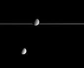 Pair to Compare
Saturn's moon Dione occults part of Saturn's distant rings while Tethys
hovers below. Dione is 1,118 kilometers (695 miles) across, while Tethys
is 1,071 kilometers, 665 miles) across.
This image offers excellent contrast with a previously released view (see PIA06629) that showed the bright, wispy markings on Dione's trailing hemisphere. The huge impact structure Odysseus (450 kilometers, or 280 miles across) is near the limb of Tethys. Compared with the battered surface of Tethys, Dione appears much smoother from this distance.
The image was taken in visible light with the Cassini spacecraft
narrow-angle camera on March 19, 2005, at a distance of approximately
2.7 million kilometers (1.7 million miles) from Saturn. The image scale
is approximately 15 kilometers (9 miles) per pixel.
(Courtesy NASA/JPL/Space Science Institute)
 Odysseus Basin
Early in the history of Tethys, an impact occurred forming
an enormous 400-kilometer impact basin named Odysseus. The impact scar
spans more than two-fifths of the satellite with a diameter slightly larger
than Saturn's moon Mimas. When Odysseus was first
created, the crater must have been deep with a high mountainous rim and
towering central peak. Over time the crater floor relaxed to the spherical shape
of the Tethys' surface, and the crater's rim and central peak collapsed.
(Similar relaxation is apparent on Jupiter's moons
Callisto and
Ganymede.)
At the time of the Odysseus impact, Tethys must have been sufficiently
warm and malleable to allow the topography to collapse. Tethys' interior
may have even been liquid. If Tethys had been colder and more brittle at the
time of impact, the moon may have been shattered. If it survived the
impact, the topography of the crater would have retained its shape similar
to Herschel crater on Mimas.
The Voyager 2 spacecraft acquired this image on August 25, 1981
from a range of 826,000 kilometers. The right most edge was missed
by the Voyager imaging system.
(Copyright 1999 by Calvin J. Hamilton)
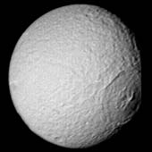
 Battered and Grooved
Having now passed closer to Tethys than the Voyager 2 spacecraft, Cassini
has returned the best-ever natural color view of this icy Saturnian moon.
As seen here, the battered surface of Tethys (1,060 kilometers, or 659 miles across) has a neutral hue. The image here is a mosaic of two footprints. Three images taken in the red, green and blue filters were taken to form a natural color composite. The result reveals a world nearly saturated with craters - many small craters lie on top of older, larger ones, suggesting an ancient surface. At the top and along the boundary between day and night, the moon's terrain has a grooved appearance.
This moon is known to have a density very close to that of water, indicating it is likely composed mainly of water ice. Its frozen mysteries await Cassini's planned close flyby in September 2005.
The view shows primarily the trailing hemisphere of Tethys, which is the side opposite the moon's direction of motion in its orbit. The image has been rotated so that north on Tethys is up.
The images comprising this color view were taken with the Cassini
spacecraft narrow angle camera on Oct. 28, 2004, at a distance of about
256,000 kilometers (159,000 miles) from Tethys and at a
Sun-Tethys-spacecraft, or phase, angle of 50 degrees. The image scale is
1.5 kilometers (0.9 miles) per pixel.
(Courtesy NASA/JPL/Space Science Institute)
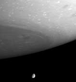 Breathtaking Vista
This dazzling view looks beyond gigantic storms near Saturn's south pole
to the small but clear disc of Tethys (1,060 kilometers, or 659 miles,
across). Clouds and ribbons of gas swirl about in the planet's atmosphere
in the foreground, while a tremendous chasm is visible on the icy moon.
The image was taken with the Cassini spacecraft narrow angle camera on
Oct. 18, 2004, at a distance of 3.9 million kilometers (2.4 million miles)
from Saturn and at a Sun-Saturn-spacecraft, or phase, angle of 61 degrees.
The view is in wavelengths of visible red light centered at 619
nanometers. The image scale is 23 kilometers (14 miles) per pixel.
(Courtesy NASA/JPL/Space Science Institute)
 Crater Odysseus Profile
This image shows a nice profile view of the
giant impact basin Odysseus (lower right-hand limb). Because Tethys was warmer when the
impact occurred, the crater floor relaxed to the spherical shape
of Tethys' surface, and the crater's rim and central peak collapsed. Towards
the upper-right limb is a portion of the immense trench Ithaca Chasma.
The Voyager 2 spacecraft acquired this image on August 25, 1981
from a range of 680,000 kilometers (420,000 miles).
(Copyright 1999 by Calvin J. Hamilton)
 Color Image of Odysseus Crater
This color image shows another nice view of the Odysseus impact basin.
It was acquired by the Voyager 2 spacecraft
from a range of 1.1 million kilometers (670,000 miles).
(Copyright 1999 by Calvin J. Hamilton)
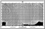 Mercator Map of Tethys
This image is a mercator map of Tethys. It was made from images taken by
the Voyager 2 spacecraft. The map covers the region from -70° to 70°
latitude.
(A. Tayfun Oner)
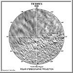 North Polar Map of Tethys
This image in a north polar stereographic projection map of Tethys
It covers latitudes 65 to 90 degrees and was made from images taken by
the Voyager 2 spacecraft.
(A. Tayfun Oner)
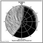 South Polar Map of Tethys
This image in a south polar stereographic projection map of Tethys
It covers latitudes 65 to 90 degrees and was made from images taken by
the Voyager 2 spacecraft.
(A. Tayfun Oner)

 Saturn
 Enceladus
 Calypso