Before I flew I was already aware of how small and vulnerable our planet is; but only when I saw it from space, in all its ineffable beauty and fragility, did I realize that human kind's most urgent task is to cherish and preserve it for future generations.
- Sigmund Jähn, German Democratic Republic
|
Table of Contents |
|
Earth From Space
|
Our perspective on Earth can be very narrow. We may not see the effects of one tree that is cut down. Only by expanding our perspective can we see entire rain forests that have been devastated. Humans can destroy in a matter of days that which nature took thousands of years to create. We might ask what harm can one factory do to the environment by not meeting proper pollution controls. The effect from space is obvious. Pictures taken by Gemini astronauts almost 30 years ago are much clearer than those taken by space shuttle astronauts today.
The following quotations are taken from astronauts who have gone into space and the effect that it had upon them:
Quotes From Astronauts
For those who have seen the Earth from space, and for the hundreds and perhaps thousands more who will, the experience most certainly changes your perspective. The things that we share in our world are far more valuable than those which divide us.
- Donald Williams, USAMy first view - a panorama of brilliant deep blue ocean, shot with shades of green and gray and white - was of atolls and clouds. Close to the window I could see that this Pacific scene in motion was rimmed by the great curved limb of the Earth. It had a thin halo of blue held close, and beyond, black space. I held my breath, but something was missing - I felt strangely unfulfilled. Here was a tremendous visual spectacle, but viewed in silence. There was no grand musical accompaniment; no triumphant, inspired sonata or symphony. Each one of us must write the music of this sphere for ourselves.
- Charles Walker, USALooking outward to the blackness of space, sprinkled with the glory of a universe of lights, I saw majesty - but no welcome. Below was a welcoming planet. There, contained in the thin, moving, incredibly fragile shell of the biosphere is everything that is dear to you, all the human drama and comedy. That's where life is; that's were all the good stuff is.
- Loren Acton, USAThe Earth was small, light blue, and so touchingly alone, our home that must be defended like a holy relic. The Earth was absolutely round. I believe I never knew what the word round meant until I saw Earth from space.
- Aleksei Leonov, USSRThe sun truly "comes up like thunder," and it sets just as fast. Each sunrise and sunset lasts only a few seconds. But in that time you see at least eight different bands of color come and go, from a brilliant red to the brightest and deepest blue. And you see sixteen sunrises and sixteen sunsets every day you're in space. No sunrise or sunset is ever the same.
- Joseph Allen, USAThe Earth reminded us of a Christmas tree ornament hanging in the blackness of space. As we got farther and farther away it diminished in size. Finally it shrank to the size of a marble, the most beautiful marble you can imagine. That beautiful, warm, living object looked so fragile, so delicate, that if you touched it with a finger it would crumble and fall apart. Seeing this has to change a man, has to make a man appreciate the creation of God and the love of God.
- James Irwin, USASuddenly, from behind the rim of the moon, in long, slow-motion moments of immense majesty, there emerges a sparkling blue and white jewel, a light, delicate sky-blue sphere laced with slowly swirling veils of white, rising gradually like a small pearl in a thick sea of black mystery. It takes more than a moment to fully realize this is Earth . . . home.
- Edgar Mitchell, USAMy view of our planet was a glimpse of divinity.
- Edgar Mitchell, USAFor the first time in my life I saw the horizon as a curved line. It was accentuated by a thin seam of dark blue light - our atmosphere. Obviously this was not the ocean of air I had been told it was so many times in my life. I was terrified by its fragile appearance.
- Ulf Merbold, Federal Republic of GermanyA Chinese tale tells of some men sent to harm a young girl who, upon seeing her beauty, become her protectors rather than her violators. That's how I felt seeing the Earth for the first time. "I could not help but love and cherish her.
- Taylor Wang, China/USA
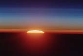 Sunset Over the Sahara Desert
This picture of a sunset over the Sahara Desert was taken by the
space shuttle crew when the shuttle was at a position over
the Sudan near the Red Sea coast.
Space shuttle crews see a sunrise or sunset every 45 minutes as they
circle the Earth at 27,300 kilometers (17,000 miles) per hour, crossing
the surface at 6.4 kilometers (4 miles) per second.
This picture illustrates the clearly defined bands of color as the sun
rises and shines throught the atmosphere.
(Courtesy NASA)
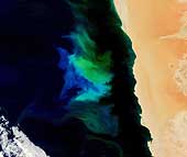 Phytoplankton Bloom, Namibia
A flash of blue and green lit the waters off Namibia in early November 2007
as a phytoplankton bloom grew and faded in the Atlantic Ocean. The bloom stretches
from north to south along hundreds of miles, although it is brightest in the
center of this image. Such blooms are common in the coastal waters off southwest
Africa where cold, nutrient-rich currents sweep north from Antarctica and
interact with the coastal shelf. At the same time, the easterly trade winds
push surface water away from the shore, allowing water from the ocean's floor
to rise to the surface, bringing with it iron and other material. The
suffusion of nutrients from both the currents and upwelling water creates
an environment where tiny surface-dwelling ocean plants thrive.
Phytoplankton blooms are so abundant off Namibia that their death and
decomposition often robs the water of dissolved oxygen.
As the plants die, they sink to the ocean floor where bacteria consume them.
There is so much plant material that the bacteria use all of the oxygen
available in the water before they finish breaking down the plants, creating
a dead-zone in the water where fish can't survive. Anaerobic bacteria, which
don't require oxygen, take over in the decomposition process, releasing
sulfur dioxide as a byproduct. The sulfur dioxide interacts with the ocean
water to create solid sulfur and hydrogen sulfide, a poisonous gas, which
eventually erupts to the surface, sometimes killing fish. Though no eruption
is readily apparent in this image, hydrogen sulfide eruptions are often
visible in satellite imagery because the solid sulfur colors the water a
milky yellow-green.
(Courtesy NASA)
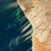 Dust Plumes and Phytoplankton Bloom off Namibia
North of the soft orange sands of the Namib Desert, streamer
of pale dust are streaming over Namibia´s Skeleton Coast in the
Moderate Resolution Imaging Spectroradiometer (MODIS) from the
Terra satellite on July 13, 2003. In the waters of the Atlantic
Ocean, colorful swirls of blue and green suggest a bloom of tiny
marine plants called phytoplankton.
(Courtesy NASA)
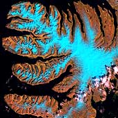
West Fjords
The West Fjords are a series of peninsulas in
northwestern Iceland. They represent less than one-eighth the
country's land area, but their jagged perimeter accounts for more
than half of Iceland's total coastline.
(Courtesy USGS)
 Radar Image of Mount Everest
This is a radar image of Mount Everest and its surroundings, along the
border of Nepal and Tibet. The peak of Mount Everest, the highest
elevation on Earth at 8,848 meters (29,030 feet), can be seen near
the center of each image. It shows an area approximately 70
kilometers by 38 kilometers (43 miles by 24 miles) that is
centered at 28.0 degrees north latitude and 86.9 degrees east
longitude. North is toward the upper left.
Many features of the Himalayan terrain are visible in the image.
Snow covered areas appear bright blue in the image which
was taken in early spring and shows deep snow cover.
The curving and branching features seen
are glaciers. Radar is sensitive to
characteristics of the glacier surfaces that are not detected
by conventional photography, such as the ice roughness, water
content and stratification. For this reason, the glaciers
show a variety of colors
(blue, purple, red, yellow, white) but
only appear as gray or white in an optical photograph.
(Courtesy NASA/JPL)
 Lost City of Ubar, Southern Oman, Arabian Peninsula
This is a radar image of the region around the site of the lost city
of Ubar in southern Oman, on the Arabian Peninsula. The ancient city
was discovered in 1992 with the aid of remote sensing data.
Archeologists believe Ubar existed from about 2800 B.C. to about
300 A.D. and was a remote desert outpost where caravans were assembled
for the transport of frankincense across the desert. The prominent,
magenta colored area is a region of large sand dunes. The prominent
green areas are rough limestone rocks, which form a rocky desert floor.
A major wadi, or dry stream bed, runs across the middle of the image
and is shown largely in white due to strong radar scattering.
(Courtesy NASA/JPL)
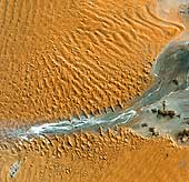 Dune Fields, Namibian Coastal Desert
Namib-Naukluft National Park is an ecological preserve
in Namibia's vast Namib Desert. Coastal winds create the tallest
sand dunes in the world here, with some dunes reaching 980 feet (300
meters) in height.
(Courtesy USGS)
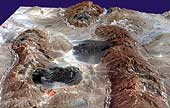
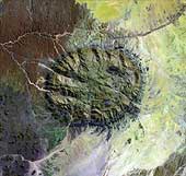 Brandberg Intrusion, Namibia
Rising unexpectedly from the heart of the Namib Desert
in northern Namibia, the Brandberg Massif is an exhumed granite
intrusion dating to some 120 million years ago. It rises to
2,606 meters (8,550 feet) and is higher than any other feature
for hundreds of kilometers.
Unique plant and animal communities thrive in its
high-altitude environment, and prehistoric cave paintings decorate
walls hidden in its steep cliffs.
Slightly south and to the west of the Brandberg is the much-eroded Messum Intrusion. Both of these intrusions reflect a period of extraordinarily widespread geological unrest in the Earth's history, which preceded the opening of the Atlantic Ocean and the effusion of vast volumes of basaltic lavas of the Karoo formation that form the Drakensberg plateau. Karoo lavas are exposed immediately to the west of the intrusion. Rocks forced aside by the upward movement of the intrusion are visible encircling the margin of the Brandberg, tilted sharply upward. Ancient gneisses, distinguished by their lineated texture, are conspicuous along the dry river valley in the center of the frame.
The existence of a set of lavas in South America of the same age and type
as those of the Karoo was used for many years by some geologists as strong
evidence that Africa and South America had once been united. However,
their arguments were not widely accepted until geophysical data
demonstrated the reality of plate tectonics.
(Courtesy USGS)
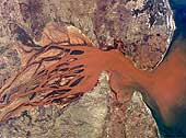 Sediment laden drainage, Betsiboka River, Madagascar
The Betsiboka is Madagascar's main river, flowing for a total of 525
kilometers (326 miles) from north of Tananarive. The river is navigable
for at least 130 kilometers (81 miles) inland and the lower reaches
pictured here are noted for their extensive rice fields. While the red
sediment being transported provides an attractive and informative example
of a river estuary, it is a symptom of an ecological disaster for
Madagascar. Humans have felled and cleared the island's natural cover of
tropical forest so extensively that soil erosion has been vastly
accelerated. Much of the sediment visible in the river represents an
irreplaceable natural asset.
Brick-red lateritic soils, the result of tropical weathering, are
responsible for the strong color of the sediments. Most of the deforestation
in Madagascar has taken place over the last 20 years, the same period
during which observations from space have been conducted. Recent
observations show that very little of the original forest remains.
(Courtesy NASA)
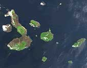 Galapagos Islands, Pacific Ocean
The Galapagos Islands, which are
part of Ecuador, sit in the Pacific Ocean about 1000 km (620 miles) west
of South America. The islands sit on the Galapagos rift, an offshoot of the
East Pacific Rise. The islands were formed by volcanic eruptions,
which took place millions of years ago. The islands straddle the equator
in a chain of 13 large island and many smaller ones. They lie
between 1° north and 1°3' south, and lies between 89 and 92° west longitude.
With the exception Isabella, the islands have high volcanic
craters at the island centers, that rise to 1,520
meters and are roughly circular in shape.
Unlike most remote islands in the Pacific, the Galapagos have gone
relatively untouched by humans over the past few millennia. As a result,
many unique species have continued to thrive on the islands. Over 95
percent of the islands' reptile species and nearly three quarters of its
land bird species cannot be found anywhere else in the world. Two of the
more well known are the Galapagos giant tortoise and marine iguanas. The
unhindered evolutionary development of the islands' species inspired
Charles Darwin to begin The Origin of Species eight years after his visit
there. To preserve the unique wildlife on the islands, the Ecuadorian
government made the entire archipelago a national park in 1959. Each year
roughly 60,000 tourists visit these islands to experience what Darwin did
over a century and a half ago.
(Courtesy NASA)
 Anticlines and salt domes, Gulf coast, Iran
One of the most spectacular examples of anticlinal fold structures
lie on the north shore of the Strait of Homuz in the Persian Gulf.
Located near the important city of Bandar Abbas, these folds form the
foothills of the Zagros Mountains, which run north-northwesterly through
Iran. The folds were formed when the Arabian shield collided with the
western Asian continental mass about 4 to 10 million years ago.
Subduction still continues slightly further east,
beneath Baluchistan, but is inactive in the Gulf itself. Although not
obvious in the photograph, the shortening expressed by the folds is
accompanied by extensive thrusting on the easterly dipping planes. All the
deformation is geologically young; the folded sediments are Paleogen and
Neogen. Simple anticlinal structures are well know as classic traps for
hydrocarbons, and some producing wells are located in the area.
The other features that are prominent in this photograph are the dark
circular patches. These represent the surface expression of salt domes
that have risen diapirically from the Cambrian Hormuz salt horizon
through the younger sediments to reach the surface. Only in a hot arid
environment such as that of the Gulf can the soluble salt escape rapid
erosion. Salt domes also are frequently favorable sites for trapping
hydrocarbons.
(Caption courtesy LPI. Picture courtesy NASA)
 Salt Glaciers
The diapirs, or salt plugs, in this image are a few of over 200 similar features
scattered about this part of the Zagros Mountains in southern Iran. This region
of folded rocks is the result of the collision between the Asian landmass and
the Arabian platform. The deeper underlying deposits of salt have been reformed
into ascending fluid-like, plastic plumes of salt. In some places these plumes
have pushed through the overlying rock units, like toothpaste extruding from a
tube, and are now visible as darkish irregular patches. Gravity has caused the
salt to flow into adjacent valleys; the resulting tongue-shaped bodies, more
than 5 km long, resemble glaciers, with arcuate ridges separated by
crevasse-like gullies and with steep sides and fronts. The darker tones are due
to clays brought up with the salt, as well as the probable accumulation of
airborne dust.
(Courtesy NASA)
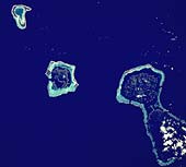 Tahaa, Raiatea, Bora Bora and Tupai Atolls, Pacific Ocean
This chain of coral-fringed islands forms the Leeward Island chain within
the French Society Islands. At bottom right are the islands of Tahaa and
Raiatea. They are old, eroded volcanoes, fringed by a coral reef.
Northward along the chain, the original central volcanoes are older and
more heavily eroded. On Bora Bora (center), the reef is prominently
developed and the island significantly eroded. The northernmost island,
Tupai, is merely an atoll, having lost any relic of the volcano around
which the reef originally grew, except for the shallow floor of the
lagoon, showing up in turquoise.
This sequence provides an excellent illustration of the hypothesis first
propounded by Charles Darwin to explain the origin of coral reefs in deep
oceans. Reef-building corals can only live in shallow waters of 20 meters
(66 feet), in temperatures over 21° centigrade (70° Fahrenheit).
Initially, corals formed fringing reefs around volcanic islands. Old
volcanoes are very rapidly eroded in tropical climates until they reach
sea level. Below sea level, the rate of erosion is much slower, and
atolls such as Tupai might
exist for long periods. If for geological reasons the original
volcano subsides below sea level at a slow enough rate, corals will
continue to build, thus preserving an atoll at the surface long after
the original volcanic edifice has been deeply submerged.
(Caption courtesy LPI/NASA)
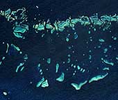 Great Barrier Reef, east coast of Australia
Colonies of coral appear vibrant blue green in this Moderate Resolution
Imaging Spectroradiometer (MODIS) image of Australia's Great Barrier
Reef. Stretching over 2000 kilometers along the northeast coast of
Australia, the Great Barrier Reef is the largest coral system that has
ever existed. It is made up of about 2,900 reefs with at least 350
different species of coral, though only about six percent are coral reefs.
Underlying sediments, twice as old as the reef itself,
indicate that the region was once above sea level. Geological evidence
shows that the reef began growing more than 25 million years ago. As the
image shows, the "reef" is in fact composed of many individual detached
reefs, separated by deep water channels. The calcareous remains of tiny
creatures called coral polyps and hydrocorals provide the basic building
material for the reefs while the remains of coraline algae and organisms
called polyzoas provide the cement that holds the structure together.
When fossilized, such reefs and the debris eroded from them form thick
limestone units.
Teaming with life, the region is home to a wide
variety of marine animals including over 1500 species of fish, sea
snakes, turtles, birds, mollusks, and dugongs. Broad Sound cuts into the
Queenland coastline towards the southern edge of the reef in this image.
The Great Barrier Reef is the largest reef on Earth at the present day.
The reasons for its size and longevity are the very stable geological
setting of the Australian platform, and the favorable oceanic circulation.
Coral cannot exist at temperatures below 21° centigrade
(70 ° Fahrenheit). The warmth of the waters of the Australian
continental shelf varies little with depth because of the stirring action
of the southeast trade winds. These winds pound the outer edge of
the reef for nine months of the year, and this also keeps the reef
supplied with seawater rich in the organic material needed by the
growing coral.
(Courtesy NASA)
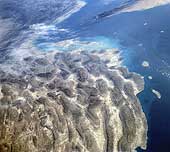
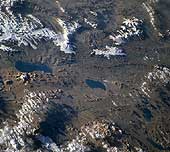 Glaciers, Lakes and Fault Zone, Tibet
The Tibet plateau is the largest and highest elevated region in the world.
The plateau is 1,200 kilometers (746 miles) from east to west and
900 kilometers (560 miles) north to south, with a mean elevation of about
4900 meters (16,000 feet). The lowlands and valleys range in elevation from
3700 meters to 4600 meters (12,000 feet
to 15,000 feet). Because the plateau rises above so much
of the atmosphere, photographs are typically brilliantly crisp and clear.
A plethora of geological features are visible in any frame. This picture
shows the northwest corner of the plateau near the point where the ground
falls away to the Tarim Basin. The impressive snow-capped mountain at top
right with well-developed valley glaciers is Muztag Ulu, which has an
elevation of 7,282 meters (23,892 feet). The
plateau was elevated as a consequence of the collision between India and
Asia, which resulted in extensive shortening by overthrusting and folding.
A second important consequence of the collision was major strike slip
faulting, facilitating the tectonic
"escape" of China like a squeezed melon seed. The linear
valley with two lakes may be the site of a strike slip fault. At the
lower right corner, two light-toned outcrops are also apparently
displaced some 300 kilometers (186 miles) by the left lateral fault.
The blue lake at center shows extensive terraces around its northern shores.
During glacial times, lake levels on the plateau stood as much as 300
meters (984 feet)
higher than at the present day. Since the end of the Ice Age, the
climate has become increasingly arid and lakes have shrunk. The bounding
Himalayan and Kun Lun mountain ranges act as effective barriers to
moisture-laden
winds.
(Courtesy NASA)
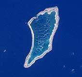 Canton Atoll, Phoenix Islands, Pacific Ocean
Canton Atoll is a good example of a long-lived coral atoll. Like Tupai, it
probably originated as a fringing reef developed around a volcanic island
that has long since disappeared. Unlike Tupai, however, it is far distant
from any above-surface volcanic structure. Its parent volcano long ago
subsided deep beneath the sea. The atoll lies only 2.5° from the
equator and is subjected to long periods of drought. Although it is the
largest island in the Phoenix group, only 9 square kilometers (3.5
square miles) rise above sea level. The island was discovered in the
early 19th century and was named after an American whaling ship wrecked
there in 1854. For several decades, American companies extracted the
valuable guano. However, in the 20th century, Canton's attraction was as
a refueling stop for aircraft on long-haul flights across the Pacific.
Hence, the island has a long runway on the north shore and the
designation, on maps, of the lagoon as a seaplane anchorage.
However, advances in aircraft design eliminated the island's role as a
refueling stop. With no economic role and insufficient soil to support
crops, the island does not support permanent habitation. Patterns of coral
heads growing within the shallow water of the lagoon are clearly visible
as a thin white network.
(Courtesy LPI/NASA. Picture 9-46-1835)
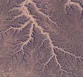 Dendritic drainage pattern, Yemen
The Republic of South Yemen lies on the edge of one of the world's great
sand seas, the Rubh-al-Khali, but even this dry desert region bears the
unmistakable imprint of flowing streams and rivers. The branching pattern
in the photograph could only have been produced by running water, draining
off the surrounding land. These filigree patterns are termed "dendritic
drainages" because of their similarity to the way in which trees branch
out into progressively finer twigs. The term comes from the Greek
dendrites, meaning tree-like.
The dry gullies or waids appear to pose something of a paradox in an area
that is apparently exceptionally arid desert, with no vestige of plant
life. Freak rainstorms and flash flooding might deepen and
extend the gullies, but they are far too infrequent at the present day to
have produced the pattern seen here. The drainage pattern is clearly a
fossil. When the Earth emerged from the last Ice Age, the Sahara and the
Rubh-al-Khali were savanna grasslands with a more temperate climate and
much higher rainfall than they experience today. Runoff from the coastal
mountains carved the dendritic drainage pattern, which was then
"fossilized" when the climate became more arid.
(Courtesy NASA)
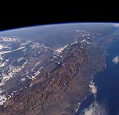 Coast and Andes Mountains, Chile
The Andes mountains form one of the longest continuous mountain ranges on
Earth, extending from the shores of the Caribbean as far south as the
Magellan Straits. Perhaps the most surprising aspect of this range is how
narrow it is over much of its length - the high part of the range is
typically less than 150 kilometers (93 miles) broad. Illustrated is the
section of the Andes near Coquimbo, Chile, where the highest peaks are
6,300 meters (20,670 feet).
Low lighting and the oblique perspective emphasize the narrowness of the
range, which forms a formidable natural obstacle, and explains how the
improbably long and thin country of Chile acquired its identity.
In this part of the range, active volcanism is absent. The Benioff zone in
this region has a very shallow dip (10°). To both north and south, the
Benioff zone dips more steeply (30°) and volcanism is well developed.
Clouds illuminated by the low sun hang over the Argentine Pampas beyond the
Andes and illustrate the marked climatic differences between different
sides of the Andes. In the south, the Chilean side of the Andes tends to be
well watered and fertile, while the pampas are in rain shadow and tend to
be very dry. Further north, the Chilean coast is exceptionally dry (and
forms the Atacama desert) while the eastern slopes are much wetter.
(Courtesy NASA)
The quotes from astronauts were taken from "The Home Planet," and many of the captions came from the LPI slide set.
Francis, Peter and Pat Jones. "Shuttle Views the Earth - Geology from Space." Center for Information and Research Services/Lunar and Planetary Institute, slide set.
Kelley, Kevin W ed. "The Home Planet." Addison-Wesley Publishing Company, New York.