Cold upon the dead volcano sleeps the gleam of dying day.
- Tennyson
| Table of Contents |
|
Animations of Martian Volcanoes Views of Martian Volcanoes References |
| Other Resources |
|
Mars Introduction Rootless Cones or Pseudocraters The Viking Mission Mars Global Surveyor |
Elysium Planitia is the second largest volcanic region on Mars. Elysium Planitia is centered on a broad dome that is 1,700 by 2,400 kilometers (1,060 by 1,490 miles) in size. It has smaller volcanoes than the Tharsis region, but a more diverse volcanic history. The three volcanoes include Hecates Tholus, Elysium Mons and Albor Tholus.
The large shield volcanoes on Mars resemble Hawaiian shield volcanoes. They both have effusive eruptions which are relatively quiet and basaltic in nature. Both have summit pits or calderas and long lava flows or channels. The biggest difference between Martian and Terrestrial volcanoes is size. The volcanoes in the Tharsis region are 10 to 100 times larger than those on Earth. They were built from large magma chambers deep within the Martian crust. The Martian flows are also much longer. This is probably due to larger eruption rates and to lower gravity. One of the reasons volcanoes of such magnitude were able to form on Mars is because the hot volcanic regions in the mantle remained fixed relative to the surface for hundreds of millions of years. On Earth, the tectonic flow of the crust across the hot volcanic regions prevent large volcanoes from forming. The Hawaiian islands were created as the Pacific plate moved northwest. These volcanoes have a relatively short life time. As the plate moves new volcanoes form and the old ones become silent.
Not all Martian volcanoes are classified as shields with effusive eruption styles. North of the Tharsis region lies Alba Patera. This volcano is comparable to Olympus Mons in its horizontal extent but not in height. Its base diameter is 1,500 kilometers (930 miles) but is less than 7 kilometers (4.3 miles) high. Ceraunius Tholus is one of the smaller volcanoes. It is about the size of the Big Island of Hawaii. It exhibits explosive eruption characteristics and probably consists of ash deposits. Tyrrhena Patera and Hadriaca Patera both have deeply eroded features which indicate explosive ash eruptions. Mt. Saint Helens is an example of a terrestrial ash eruption.
This set of images was chosen to show some of the best examples of volcanic landforms on Mars.
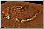
 Tharsis Montes
The alignment of the three shield
volcanoes that make up the Tharsis [THAR-siss] Montes region is
clearly evident in this view. They are named Ascraeus Mons (top right),
Pavonis Mons (middle) and Arsia Mons (bottom). Olympus Mons can be seen
in the upper left hand corner. The three volcanoes are each somewhat
smaller than Olympus Mons, varying from 350 to 450 kilometers (220 to
280 miles) in horizontal extent and each rising about 15 kilometers (9
miles) above the surrounding plains. The Tharsis Montes are located on
the crest of a broad uplift of the Martian crust so that their summits
are at about the same elevation as the summit of Olympus Mons. The
fractures southeast of Pavonis Mons are named Noctis Labyrinthus; this
region merges with the enormous Vallis Marineris canyon system to the
east.
(Copyright by Calvin J. Hamilton)
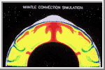 Mantle Convection
This image shows a computer simulation of processes in the interior of
Mars that could have produced the Tharsis region. The color differences
are variations in temperature. Hot regions are red and cold regions are
blue and green, with the difference between the hot and cold regions
being as much as 1000°C (1800°F).
Because of thermal expansion, hot rock has
a lower density than cold rock. These differences in density cause the
hot material to rise toward the surface and the cold material to sink
into the interior, creating a large-scale circulation known as mantle
convection. This type of mantle flow produces
plate tectonics on Earth.
The hot, rising material tends to push the surface of the planet up,
and the cold, sinking material tends to pull the surface down. These
motions contribute to the overall topography of the planet. This
deformation of the planet's surface is shown in gray along the outer
surface of the planet in this image. The amount of deformation is highly
exaggerated to make it visible here. The actual uplift in Tharsis is
estimated to be about 8 kilometers (5 miles) at its center. This uplift
also stretches the crust, forming features such as
grabens and Valles Marineris. In
addition, the hot, rising material may melt as it approaches the
surface, producing volcanic activity.
(Courtesy Walter S. Kiefer and Amanda Kubala, LPI)
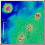
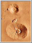
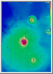 Elysium Planitia
Elysium Planitia is the second largest volcanic region on Mars. It is
located on a broad dome that is 1,700 by 2,400 kilometers (1,060 by
1,490 miles) in size. The volcanoes Hecates Tholus, Elysium Mons and
Albor Tholus can be seen going from north to south (top to bottom) in
this image. Hectas Tholus is 160 by 175 kilometers (100 by 109 miles)
in size with a caldera complex 11.3 by 9.1 kilometers (7 by 5.7 miles)
in size. Elysium Mons is the largest volcano in this region. It has base
dimensions of 420 by 500 by 700 kilometers (260 by 310 by 435 miles)
and rises 13 kilometers (8 miles) above the surrounding plains. Its
summit caldera is about 14.1 kilometers (8.8 miles) in diameter. Albor
Tholus measures 160 by 150 kilometers (100 by 93 miles) with a summit
caldera of 35 by 30 kilometers (22 by 19 miles). Its northwest flanks
have been partially buried by lava flows from Elysium Mons.
(Copyright Calvin J. Hamilton)
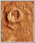
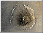 Olympus Mons
Olympus [oh-LIM-pus] Mons is the largest volcano known in the solar
system. It is classified as a
shield volcano, similar to
volcanoes in Hawaii. The central edifice of
Olympus Mons has a summit caldera 24
kilometers (15 miles) above the surrounding plains. Surrounding the
volcano is an outward-facing scarp 550
kilometers (342 miles) in diameter and several kilometers high. Beyond
the scarp is a moat filled with lava, most
likely derived from Olympus Mons. Farther out is an aureole of
characteristically grooved terrain, just visible at the top of the frame.
(Courtesy USGS/NASA)
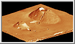
The Majestic Olympus Mons
This 3D image of Olympus Mons was created using the USGS color
Mars mosaic and Mars digital elevation model.
The final image shows Olympus as it would be seen from the northeast.
It is possible that volcanoes of such magnitude were able to form on
Mars because the hot volcanic regions in the mantle remained fixed
relative to the surface for hundreds of millions of years.
(Copyright by Calvin J. Hamilton)
 Olympus Mons, 1998
Olympus Mons is a mountain of mystery. Taller than three Mount Everests
and about as wide as the entire Hawaiian Island chain, this giant volcano
is nearly as flat as a pancake. That is, its flanks typically only slope
2° to 5°.
The Mars Global Surveyor obtained this spectacular wide-angle
view of Olympus Mons. In this view, north
is to the left and east is up.
The image was taken on a cool, crisp winter morning. The west side of
the volcano (lower portion of view, above) was clear and details on
the surface appear very sharp. The skies above the plains to the east
of Olympus Mons (upper portion of view) were cloudy. Clouds were
lapping against the lower east flanks of this 26 kilometers (16 miles)
high volcano, but the summit skies were clear.
(Courtesy Malin Space Science Systems/NASA)
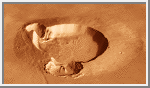
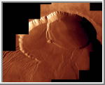 Olympus Mons Caldera Mosaic
This high-resolution image shows the Olympus Mons caldera located
24 kilometers (15 miles) above the surrounding martian plains.
The caldera is about 80 kilometers across with walls that are 2.4 to 2.8
kilometers deep. Calderas are produced when the roof of the magma chamber
collapses due to removal of magma by voluminous eruptions or subterranean
magma withdrawal.
This mosaic is constructed using pictures from the orbits 473S and 474S
of Viking 1 near the end of its mission in 1980. As
Viking 1 was near the lowest part of its orbit and moving very fast
relative to the ground targets these pictures were shuttered using image
motion compensation.
(Courtesy A. Tayfun Oner)
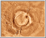
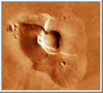
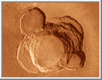 Ascraeus Mons Summit
This complex caldera
is composed of several discrete centers of collapse where the older
collapse features are cross-cut by more recent collapse events. The
lowermost circular floor preserves the last lava flooding event that
followed the last major collapse. The southern wall of the caldera has
at least 3 kilometers (1.9 miles) of vertical relief with an average
slope of at least 26° (from horizontal). The caldera complex
truncates several lava flows, indicating that the flows predate the
collapse event and that their source areas have been destroyed by the
caldera formation.
(Copyright Calvin J. Hamilton; caption by LPI)
For an 832x778 GIF image (337K) of the entire volcano click
HERE.
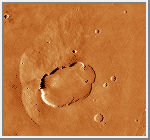
 Arsia Mons
The caldera on Arsia Mons is considerably larger than the calderas on
either Ascraeus Mons or Pavonis Mons. However, the last major collapse
event on Arsia Mons was followed by a substantial outpouring of lava
within the caldera. The caldera rim has been breached on the southwest
side while the caldera floor lavas bury portions of the northeast rim.
Aligned between these breaks in the caldera is a series of very subdued
domes on the caldera floor, perhaps representing localized sources of the
lava that flooded the caldera. The flaks of the shield have been deeply
eroded near the locations of the breaks in the caldera rim and lava flows
extend away from the volcanoes at these embayments.
(Copyright Calvin J. Hamilton; caption by LPI)
 Apollinaris Patera
This view of Apollinaris Patera, shows characteristics of an
explosive origin and an
effusive origin. Incised valleys in
most of the flanks of Apollinaris Patera indicates
ash deposits and an explosive origin. On
the west side (left), landslides that have shaped its surface also
indicate ash deposits. Towards the south flank, a large fan of material
flowed out of the volcano. This indicates an effusive origin. Perhaps
during its early development Apollinaris Patera had an explosive origin
with effusive eruptions taking place later on.
(Copyright Calvin J. Hamilton)
 Ceraunius Tholus and Uranius Tholus
Ceraunius Tholus (bottom) shows several incised valleys cut into its
flanks which indicate that it was easily eroded and probably consists
of ash deposits due to
explosive activity. The lower flanks
of the volcano have been buried beneath the plains material. Ceraunius
Tholus is about the size of the Big Island of Hawaii. Uranius Tholus
(Top) also shows similar characteristics to Ceraunius Tholus. A major
impact crater, just above Ceranius Tholus, postdates the plains material
and volcano. However, a prominent delta of probable volcanic material
was emplaced within the impact crater at the mouth of a sinuous channel
that extends up the flank of Cerauius Tholous to the summit crater.
(Copyright Calvin J. Hamilton; caption by LPI)
 Ceraunius Tholus and Uranius Tholus - 3D
This is a three dimensional view of Ceraunius Tholus (right)
and Uranius Tholus (left). The view is from the northwest.
(Copyright Calvin J. Hamilton)
 Tharsis Tholus
Tharsis Tholus measures about 150 kilometers (93 miles) across and 8
kilometers (5 miles) high. The east and west flanks are indented giving
it a strange appearance. One possible cause for its appearance is that
when the lava supply drained away, the center of the volcano collapsed.
An alternative is that big slump areas carried off portions of the
flanks, giving it the broken appearance.
(Copyright Calvin J. Hamilton)
 Uranius Patera
Uranius Patera is about the size of the Big Island of
Hawaii. It is about 3 kilometers (1.9 miles)
in height. It has shallow slopes and lava flows. This indicates
an effusive origin. The center caldera
was formed when lava drained away and the volcano collapsed.
(Copyright Calvin J. Hamilton)
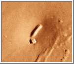
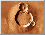 Ulysses Patera
This feature is an example of a class of volcanoes that are considerably
smaller than the broad shield volcanoes. The summit consists of a single,
very circular caldera with a smooth floor that predates the ejecta from
two large impact craters. The lower flanks of the volcano, including
portions of the impact craters, have been buried by the material that
makes up the surrounding plains. This superpositional relationship
indicates that the plains were emplaced subsequent to both the volcano
and the large impact craters on the volcano. The plains are probably made
up of lava supplied from Tharsis Montes that flowed down the sides of
the broad uplift associated with the Tharsis shields. Both the plains and
the volcano are cut by a graben,
indicating tectonic activity subsequent to the emplacement of the plains.
(Copyright Calvin J. Hamilton, and LPI)
 Ulysses Patera in 3D
This shows perspective view of Ulysses Patera looking from the north.
(Copyright Calvin J. Hamilton)
 Tyrrhena Patera
Volcanoes located within the densely cratered southern highlands have a
very different morphology from either the Tharsis or Elysium volcanoes.
Tyrrhena Patera has very little vertical relief (< 2 kilometers),
resulting in very shallow flank slopes. The flanks of the volcano are
deeply eroded with many broad channels that radiate from the summit
region. The low relief and easily erodible nature of the flank materials
has been interpreted to indicate that the bulk of the volcano is
composed of pyroclastic
ash deposits. This interpretation implies
that the style of eruption for the highland volcanoes like Tyrrhena
Patera is significantly different from the repeated effusion of fluid
lavas that built up the shield volcanoes.
(Copyright Calvin J. Hamilton; caption by LPI)
 Hadriaca Patera
Much like Tyrrhena Patera, Hadriaca Patera is a deeply eroded feature
having little vertical relief. Several impact craters are superimposed
on the eroded flanks, indicating a great age for this volcano. A large
channel has its source near the southeastern margin of the volcano; the
fluid that carved the channel flowed southwest into the interior of the
Hellas basin.
(Copyright Calvin J. Hamilton; caption by LPI)
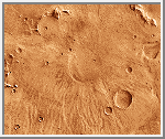
 Tempe Volcano
Volcanic construct on Mars are not all enormous mountains like the
Tharsis Montes. This elongate hill surmounted by a linear depression
is interpreted to be a product of localized but not extremely
voluminous eruptions. If the volcanic material was emplaced by ejection
along a ballistic trajectory, this feature may be similar to a
terrestrial cinder cone. This feature is aligned with several
grabens in the area so that a
structural weakness in the crust may have provided the conduit for
the volcanic material to reach the surface.
(Copyright Calvin J. Hamilton; caption by LPI)
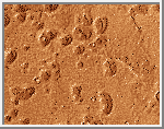 Hellas Mounds
Numerous small mounds having summit craters are found in various
locations on Mars. The mounds shown here are east of the Hellas
basin. These features have been interpreted to be pseudocraters
created by localized phreatic
explosions where lava interacts with volatile-rich ground.
Most of the mounds are between
400 meters (1,312 feet) to 1 kilometer (.62 miles) across. Many have
slotlike summit vents. However, images presently available do not
have sufficient resolution to show conclusive evidence of a volcanic
origin for the mounds.
(Copyright Calvin J. Hamilton; caption by LPI)
Beatty, J. K. and A. Chaikin, eds. The New Solar System. Massachusetts: Sky Publishing, 3rd Edition, 1990. (See Chapter 5, pp. 57-59.)
Carr M. H. "The Volcanoes of Mars." Scientific American, 1975, 234, 32-43.
Carr M. H. The Surface of Mars. Yale University Press, New Haven, 1981. (See Chapter 7, pp. 87-113.)
Greeley R. and Spudis P. D. "Volcanism on Mars." Reviews of Geophysics and Space Physics, 1981, 19, 13-41.
Kiefer, Walter S., Allan H. Treiman, and Stephen M. Clifford. The Red Planet: A Survey of Mars - Slide Set. Lunar and Planetary Institute.
Mutch T. A., Arvidson R. E., Head J. W. III, Jones K. L., and Saunders R. S. The Geology of Mars. Princeton University Press, Princeton, 1976. (See Chapter 4, pp. 151-201.)
Robinson, Mark. "Exploring Small Volcanoes on Mars." Astronomy, April 1994, pp. 30-37.
Zimbelman, James R. Volcanoes on Mars - Slide Set. Lunar and Planetary Institute.