By turns hot embers from her entrails fly,
And flakes of mountain flame that arch the sky.
-Virgil's Aeneid
|
Table of Contents |
|
Terrestrial Volcanoes
|
|
Earth's Volcanoes |
|
Volcanoes on Other Worlds |
|
More Information |
 |
| Mount St. Helens [more] |
Ironically, these volcanic soils and inviting terranes have attracted, and continue to attract, people to live on the flanks of volcanoes. Thus, as population density increases in regions of active or potentially active volcanoes, mankind must become increasingly aware of the hazards and learn not to "crowd" the volcanoes. People living in the shadow of volcanoes must live in harmony with them and expect, and should plan for, periodic violent unleashings of their pent-up energy.
On August 24, A.D. 79, Vesuvius Volcano suddenly exploded and destroyed the Roman cities of Pompeii and Herculaneum. Although Vesuvius had shown stir-rings of life when a succession of earthquakes in A.D. 63 caused some damage, it had been literally quiet for hundreds of years and was considered "extinct." Its surface and crater were green and covered with vegetation, so the eruption was totally unexpected. Yet in a few hours, hot volcanic ash and dust buried the two cities so thoroughly that their ruins were not uncovered for nearly 1,700 years, when the discovery of an outer wall in 1748 started a period of modern archeology. Vesuvius has continued its activity intermittently ever since A.D 79 with numerous minor eruptions and several major eruptions occurring in 1631, 1794, 1872, 1906 and in 1944 in the midst of the Italian campaign of World War II.
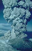
In the United States on March 27, 1980, Mount St. Helens Volcano in the Cascade Range, southwestern Washington, reawakened after more than a century of dormancy and provided a dramatic and tragic reminder that there are active volcanoes in the "lower 48" States as well as in Hawaii and Alaska.The catastrophic eruption of Mount St. Helens on May 18, 1980, and related mudflows and flooding caused significant loss of life (57 dead or missing) and property damage over $1.2 billion). Mount St. Helens is expected to remain intermittently active for months or years, possibly even decades.
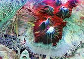
The word volcano comes from the little island of Vulcano in the Mediterranean Sea off Sicily. Centuries ago, the people living in this area believed that Vulcano was the chimney of the forge of Vulcan--the blacksmith of the Roman gods. They thought that the hot lava fragments and clouds of dust erupting from Vulcano came from Vulcan's forge as he beat out thunderbolts for Jupiter, king of the gods, and weapons for Mars, the god of war. In Polynesia the people attributed eruptive activity to the beautiful but wrathful Pele, Goddess of Volcanoes, whenever she was angry or spiteful. Today we know that volcanic eruptions are not super natural but can be studied and interpreted by scientists. (Abstracted from Tillings)

The following video clips are take from "Understanding Volcanic Hazards", © 1995, International Association of Volcanology and Chemistry of Earth's Interior (IAVCEI).
- Volcanic Ash Fallout.
- Damage Caused by Ash Fallout.
- Volcanic Ash Flows.
- Damage Caused by Mount St. Helens Ash Flows.
- Lava Flows (Sound).
- Advancing Lava Flows (Sound).
- Oceanic Volcano.
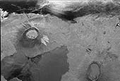
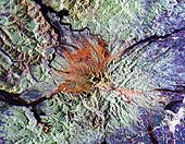
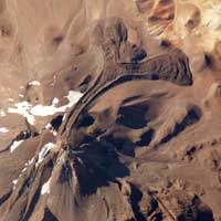 Llullaillaco Volcano
The summit of South America's Llullaillaco Volcano has an elevation of 22,110 feet above sea level, making it the highest historically active volcano in the world. The current stratovolcano--a cone-shaped volcano built from successive layers of thick lava flows and eruption products like ash and rock fragments--is built on top of an older stratovolcano. The last explosive eruption of the volcano, based on historical records, occurred in 1877.
This photograph of Llullaillaco, taken from aboard the International Space Station, illustrates an interesting volcanic feature known as a coulée. Coulées are formed from highly viscous, thick lavas that flow onto a steep surface. As they flow slowly downwards, the top of the flow cools and forms a series of parallel ridges oriented at 90 degrees to the direction of flow (somewhat similar in appearance to the pleats of an accordion). The sides of the flow can also cool faster than the center, leading to the formation of wall-like structures known as flow levees. Llullaillaco is also a well-known archaeological site; the mummified remains of three Inca children, ritually sacrificed 500 years ago, were discovered on the summit in 1999.
(Courtesy NASA)
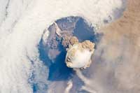 Sarychev Volcano
A fortuitous orbit of the International Space Station allowed the
astronauts this striking view of Sarychev volcano (Russia's Kuril
Islands, northeast of Japan) in an early stage of eruption on June
12, 2009. Sarychev Peak is one of the most active volcanoes in the
Kuril Island chain and is located on the northwestern end of Matua Island.
Prior to June 12, the last explosive eruption had occurred in 1989 with eruptions in 1986, 1976, 1954 and 1946 also producing lava flows. Commercial airline flights were diverted from the region to minimize the danger of engine failures from ash intake. This detailed photograph is exciting to volcanologists because it captures several phenomena that occur during the earliest stages of an explosive volcanic eruption.
The main column is one of a series of plumes that rose above Matua
Island (48.1 degrees north latitude and 153.2 degrees east longitude)
on June 12. The plume appears to be a combination of brown ash and white
steam. The vigorously rising plume gives the steam a bubble-like
appearance; the surrounding atmosphere has been shoved up by the shock
wave of the eruption. The smooth white cloud on top may be water
condensation that resulted from rapid rising and cooling of the air mass
above the ash column, and is probably a transient feature (the eruption
plume is starting to punch through). The structure also indicates that
little to no shearing winds were present at the time to disrupt the
plume. By contrast, a cloud of denser, gray ash -- most probably a
pyroclastic flow -- appears to be hugging the ground, descending from
the volcano summit. The rising eruption plume casts a shadow to the
northwest of the island (bottom center). Brown ash at a lower altitude
of the atmosphere spreads out above the ground at upper right. Low-level
stratus clouds approach Matua Island from the east, wrapping around the
lower slopes of the volcano. Only about 1.5 kilometers of the coastline
of Matua Island (upper center) can be seen beneath the clouds and ash.
(Courtesy NASA)
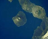
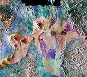
 Isla Isabella
This is an image showing part of Isla Isabella in the western
Galapagos Islands.
The western Galapagos Islands, which lie about 1,200 kilometers
(750 miles) west of Ecuador in the eastern Pacific, have six
active volcanoes similar to the volcanoes found in Hawaii. These
volcanoes reflect the volcanic processes that occur where the
ocean floor is created. Since
the time of Charles Darwin's visit to the area in 1835, there
have been over 60 recorded eruptions on these volcanoes. This
SIR-C/X-SAR image of Alcedo and Sierra Negra volcanoes shows the
rougher lava flows as bright features, while
ash deposits and
smooth pahoehoe lava flows appear dark. A small portion of Isla
Fernandina is visible in the extreme upper left corner of the
image. (Courtesy NASA/JPL)
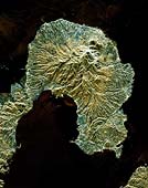
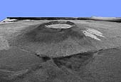 Isla Isabella in 3D
This is a three-dimensional view of Isabela, one of the Galapagos
Islands located off the western coast of Ecuador, South America.
(Courtesy NASA/JPL)
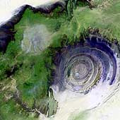 Richat Structure
The so-called Richat Structure is a geological
formation in the Maur Adrar Desert in the African country of
Mauritania. Although it resembles an impact crater, the Richat
Structure formed when a volcanic dome hardened and gradually eroded,
exposing the onion-like layers of rock.
(Courtesy USGS)
 Galapagos Islands
This image of the Galapagos Islands was taken from the space shuttle
using a hand held camera. There are seven
shield volcanoes in this
area (Fernandina, Ecuador, Wolf, Darwin, Alcedo, Sierra Negra, and Azul)
which collectively have erupted more than sixty times this century.
Unlike Hawaii, these volcanoes are infrequently studied due to their
inaccessibility and delicate ecology. In addition, the rugged terrain,
lack of water and field support make these volcanoes difficult to
map and study in the field. (Courtesy NASA/JPL)
 Mount Pinatubo
This is a false color image of the area around
Mount Pinatubo in the Philippines. The area shown is
approximately 45 by 68 kilometers (28 by 42 miles). The main
volcanic crater on Mount Pinatubo produced by the June 1991
eruptions, and the steep slopes on the upper flanks of the
volcano, are easily seen in this image. The red color on the
high slopes show the rougher
ash deposited during the 1991
eruption. The dark drainages are the smooth mudflows which
continue to flood the river valleys after heavy rain.
The 1991 eruption of Mount
Pinatubo in the Philippines is well known for its near-global
effects on the atmosphere and climate due to the large amount of
sulfur dioxide that it injected into the upper atmosphere. What
is less widely known is that even today the volcano continues to
be a major hazard to the people who have returned to the area
around the volcano. Dangerous mudflows (called "lahars") are
often generated by heavy rains, and these can still sweep down
river valleys and wash out roads and villages, or bury low lying
areas in several meters of mud and volcanic debris. These
mudflows will continue to be a severe hazard around Pinatubo for
the next 10 to 15 years. (Courtesy NASA/JPL)
 Virunga Volcano Chain
This is a false-color radar image of Central Africa, showing
the Virunga volcano chain along the borders of Rwanda, Zaire,
and Uganda. This area is home to the endangered mountain
gorillas. The image was acquired on October 3, 1994.
The dark area at the top of the image is
Lake Kivu, which forms the border between Zaire (to the
right) and Rwanda (to the left). In the center of the image
is the steep cone of Nyiragongo volcano, rising 3,465 meters
(11,369 feet) high, with its central crater now occupied by
a lava lake. To the left are three volcanoes, Mount
Karisimbi, rising 4,500 meters (14,800 feet) high; Mount
Sabinyo, rising 3,600 meters (12,000 feet) high; and Mount
Muhavura, rising 4,100 meters (13,500 feet) high. To their
right is Nyamuragira volcano, which is 3,053 meters (10,017
feet) tall, with radiating lava flows dating from the 1950s
to the late 1980s. These active volcanoes constitute a
hazard to the town of Goma, Zaire, and the nearby Rwandan
refugee camps, located on the shore of Lake Kivu at the top
left. (Courtesy NASA/JPL)
 Mount Rainier, Washington
This is a radar image of Mount Rainier in Washington state. The
volcano last erupted about 150 years ago and numerous large
floods and debris flows have originated on its slopes during the
last century. Today the volcano is heavily mantled with glaciers
and snowfields. More than 100,000 people live on young volcanic
mudflows less than 10,000 years old and, consequently, are
within the range of future, devastating mudslides.
North is toward the top left of the image.
Forested regions are pale green in color; clear cuts and bare
ground are bluish or purple; ice is dark green and white. The
round cone at the center of the image is the 14,435-foot (4,399-
meter) active volcano, Mount Rainier. On the lower slopes is a
zone of rock ridges and rubble (purple to reddish) above
coniferous forests (in yellow/green).
(Courtesy NASA/JPL)
Kliuchevskio Volcano, Russia
This is an image of the area of Kliuchevskoi volcano,
Kamchatka, Russia, which began to erupt on September 30,
1994. Kliuchevskoi is the blue triangular peak in the
center of the image, toward the left edge of the bright red
area that delineates bare snow cover.
The image was acquired on October 5, 1994. It
shows an area approximately 75 kilometers by 100 kilometers
(46 miles by 62 miles) that is centered at 56.07 degrees
north latitude and 160.84 degrees east longitude. North is
toward the bottom of the image.
The Kamchatka volcanoes are
among the most active volcanoes in the world. The volcanic
zone sits above a tectonic plate boundary, where the Pacific
plate is sinking beneath the northeast edge of the Eurasian
plate. In addition to Kliuchevskoi, two other active volcanoes are
visible in the image. Bezymianny, the circular crater above
and to the right of Kliuchevskoi, contains a slowly growing
lava dome. Tolbachik is the large volcano with a dark
summit crater near the upper right edge of the red snow
covered area. The Kamchatka River runs from right to left
across the bottom of the image. The current eruption of
Kliuchevskoi included massive ejections of gas, vapor and
ash, which reached altitudes of 15,000 meters (50,000 feet).
Melting snow mixed with volcanic ash triggered mudflows on
the flanks of the volcano. Paths of these flows can be seen
as thin lines in various shades of blue and green on the
north flank in the center of the image.
(Courtesy NASA/JPL)
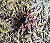
 Unzen Volcano, Japan
This is a space radar image of the area around the Unzen
volcano, on the west coast of Kyushu Island in southwestern
Japan. Unzen, which appears in this image as a large
triangular peak with a white flank near the center of the
peninsula, has been continuously active since a series of
powerful eruptions began in 1991. The image was acquired
on April 15, 1994. The image shows an area
41.5 kilometers by 32.8 kilometers (25.7 miles by 20.3
miles) that is centered at 32.75 degrees north latitude and
130.15 degrees east longitude. North is toward the upper
left of the image.
The city of Shimabara sits along the coast at the foot of
Unzen on its east and northeast sides. At the summit of
Unzen a dome of thick lava has been growing continuously
since 1991. Collapses of the sides of this dome have
generated deadly avalanches of hot gas and rock known as
pyroclastic flows.
(Courtesy NASA/JPL)
The introduction to this page along with The Nature of Volcanoes and Principal Types of Volcanoes were adapted from the U.S. Geological Survey's publication, Volcanoes, by Robert Tilling.
- Carr M. H. and Greeley R. Volcanic Features of Hawaii: A Basis for Comparison with Mars. NASA SP-403, 1980.
- Cattermole P. Planetary Volcanism. Ellis Horwood, Chichester, England.
- Decker R. W. and Decker B. B. Mountains of Fire. Cambridge University, New York, 1991.
- McDonald G. A., Abbott A. T., and Peterson F. L. Volcanos in the Sea. University of Hawaii, Honolulu, 1986.
- Mouginis-Mark, Peter. Volcanic Features of Hawaii and Other Worlds. Lunar and Planetary Institute, slide set.
- Tilling Robert I. Volcanoes. U.S. Geological Survey.