|
Mars Exploration Rover Mission |
|
|
|
|
|
|
|
|
|
|
|
|
|
|
|
|
|
Other Martian Missions |
|
| |
Mars Topics |
|
|
|
Moons of Mars |
Deimos,
Phobos
|
|
The Best of Mars Opportunity Lander Images
This gallery is designed to show some of the best Opportunity Rover Mission Images.
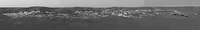
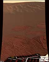
 'Payson' Panorama by Opportunity
The panoramic camera aboard NASA's Mars Exploration Rover Opportunity
acquired this panorama of the "Payson" outcrop on the western edge of
"Erebus" Crater during Opportunity's sol 744 (Feb. 26, 2006). From this
vicinity at the northern end of the outcrop, layered rocks are observed
in the crater wall, which is about 1 meters (3.3 feet) thick. The view
also shows rocks disrupted by the crater-forming impact event and
subjected to erosion over time.
To the left of the outcrop, a flat, thin layer of spherule-rich soils
overlies more outcrop materials. The rover is currently traveling down
this "road" and observing the approximately 25-meter (82-foot) length of
the outcrop prior to departing Erebus crater.
The panorama camera took 28 separate exposures of this scene, using four
different filters. The resulting panorama covers about 90 degrees of
terrain around the rover. This approximately true-color rendering was
made using the camera's 753-nanometer, 535-nanometer and 423-nanometer
filters. Image-to-image seams have been eliminated from the sky portion
of the mosaic to better simulate the vista a person standing on Mars would
see.
(Courtesy NASA/JPL-Caltech/USGS/Cornell)
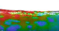 Hematite in the Martian Soil
This map of a portion of the small crater currently encircling the Mars
Exploration Rover Opportunity shows where crystalline hematite resides.
Red and orange patches indicate high levels of the iron-bearing mineral,
while blue and green denote low levels. The northeastern rock outcropping
lining the rim of the crater does not appear to contain much hematite. Also
lacking hematite are the rover's airbag bounce marks. This image consists
of data from Opportunity's miniature thermal emission spectrometer
superimposed on an image taken by the rover's panoramic camera.
(Courtesy NASA/JPL/ASU)
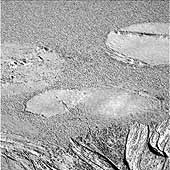
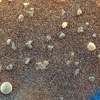 Mars Under the Microscope
This magnified look at the martian soil near the Mars Exploration Rover Opportunity's landing site, Meridiani Planum, shows coarse grains sprinkled over a fine layer of sand. The image was captured on the 10th day, or sol, of the rover's mission by its microscopic imager, located on the instrument deployment device, or "arm." Scientists are intrigued by the spherical rocks, which can be formed by a variety of geologic processes, including cooling of molten lava droplets and accretion of concentric layers of material around a particle or "seed".
The examined patch of soil is 3 centimeters (1.2 inches) across. The circular grain in the lower left corner is approximately 3 millimeters (.12 inches) across, or about the size of a sunflower seed.
This stretched color composite was obtained by merging images acquired with the orange-tinted dust cover open and closed. The varying hints of orange suggest differences in mineral composition. The blue tint at the lower right corner is a tag used by scientists to indicate that the dust cover is closed.
(Courtesy NASA/JPL/USGS)
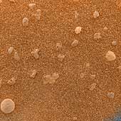 Mars Under the Microscope
This magnified look at the martian soil near the Mars Exploration Rover Opportunity's landing site, Meridiani Planum, shows coarse grains sprinkled over a fine layer of sand. The image was captured on the 10th day, or sol, of the rover's mission by its microscopic imager, located on the instrument deployment device, or "arm." Scientists are intrigued by the spherical rocks, which can be formed by a variety of geologic processes, including cooling of molten lava droplets and accretion of concentric layers of material around a particle or "seed".
The examined patch of soil is 3 centimeters (1.2 inches) across. The circular grain in the lower left corner is approximately 3 millimeters (.12 inches) across, or about the size of a sunflower seed.
This color composite was obtained by merging images acquired with the orange-tinted dust cover in both its open and closed positions. The blue tint at the lower right corner is a tag used by scientists to indicate that the dust cover is closed.
(Courtesy NASA/JPL/USGS)
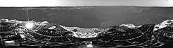
 As Far as Opportunity's Eye Can See
This expansive view of the martian real estate surrounding the Mars
Exploration Rover Opportunity is the first 360 degree, high-resolution
color image taken by the rover's panoramic camera. The airbag marks,
or footprints, seen in the soil trace the route by which Opportunity
rolled to its final resting spot inside a small crater at Meridiani
Planum, Mars. The exposed rock outcropping is a future target for
further examination. This image mosaic consists of 225 individual frames.
(Courtesy NASA/JPL/Cornell)
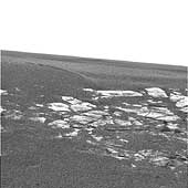
 A Hole in One
The interior of a crater surrounding the Mars Exploration Rover Opportunity at Meridiani Planum on Mars can be seen in this color image from the rover's panoramic camera. This is the darkest landing site ever visited by a spacecraft on mars. The rim of the crater is approximately 10 meters (32 feet) from the rover. The crater is estimated to be 20 meters (65 feet) in diameter. Scientists are intrigued by the abundance of rock outcrops dispersed throughout the crater, as well as the crater's soil, which appears to be a mixture of coarse gray grains and fine reddish grains.
Data taken from the camera's near-infrared, green and blue filters were combined to create this approximate true color picture, taken on the first day of Opportunity's journey. The view is to the west-southwest of the rover.
(Courtesy NASA/JPL/Cornell)
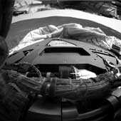
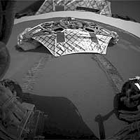 Opportunity on Its Own
This image captured by the Mars Exploration Rover Opportunity's rear
hazard-identification camera shows the now-empty lander that carried the rover
283 million miles to Meridiani Planum, Mars. Engineers received confirmation
that Opportunity's six wheels successfully rolled off the lander and onto
martian soil at 3:01 a.m. PST, January 31, 2004, on the seventh martian day,
or sol, of the mission. The rover is approximately 1 meter (3 feet) in front
of the lander, facing north.
(Courtesy NASA/JPL/Cornell)
 Not of this Earth
This sweeping look at the unusual rock outcropping near the Mars Exploration
Rover Opportunity was captured by the rover's left panoramic camera. Scientists
believe the layered rocks are either volcanic ash deposits, or sediments laid
down by wind or water. Opportunity landed at Meridiani Planum, Mars on January
24 at 9:05 p.m. PST.
(Courtesy NASA/JPL/Cornell)
 A Curious Landscape
This "postcard" from the panoramic camera on the Mars Exploration Rover Opportunity shows the view of the martian landscape southwest of the rover. The image was taken in the late martian afternoon at Meridiani Planum on Mars, where Opportunity landed at approximately 9:05 p.m. PST on Saturday, January 24, 2004.
(Courtesy NASA/JPL/Cornell)
 First Look Behind Opportunity
This image taken by the Mars Exploration Rover Opportunity's hazard-identification camera
shortly after the rover successfully landed at Meridiani Planum shows the view from behind the rover.
(Courtesy NASA/JPL/Cornell)
First Look Behind Opportunity
This image taken by the Mars Exploration Rover Opportunity's hazard-identification camera
shortly after the rover successfully landed at Meridiani Planum shows the view from behind the rover.
(Courtesy NASA/JPL/Cornell)
 First Panoramic Look at Meridiani Planum, Mars
This 360-degree panorama is one of the first images beamed back to Earth from the Mars Exploration
Rover Opportunity shortly after it touched down at Meridiani Planum, Mars. The image was captured
by the rover's navigation camera.
(Courtesy NASA/JPL)
 Meridiani Planum in Color
This color image shows the martian landscape at Meridiani Planum, where the Mars Exploration Rover
Opportunity successfully landed at 9:05 p.m. PST on Saturday. This is one of the first images beamed
back to Earth from the rover shortly after it touched down.
(Courtesy NASA/JPL/Cornell)
 Airbag Impressions in Soil
This image taken by the Mars Exploration Rover Opportunity's panoramic camera shows where the rover's airbags left impressions in the martian soil. The drag marks were made after the rover successfully landed at Meridiani Planum and its airbags were retracted. The rover can be seen in the foreground.
(Courtesy NASA/JPL/Cornell)
|